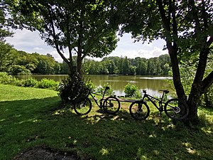
Marstadter See
| Marstadter See | ||
|---|---|---|

|
||
| View of the Marstadter See (2019) | ||
| Geographical location |
Tauberland
|
|
| Drain | Wurmgraben → Wittigbach → Grünbach → Tauber → Main → Rhine → North Sea | |
| Data | ||
| Coordinates | 49 ° 33 '44.2 " N , 9 ° 48' 17.4" E | |
|
|
||
| Altitude above sea level | 315 m above sea level NHN | |
| surface | 1,943 ha | |
| Catchment area | 90 ha | |
|
particularities |
Headland, island |
|
The Marstadter See was created several centuries ago southeast of the Lauda-Königshofener hamlet of Marstadt.
location
The 1.9 hectare Marstadter See is located in the Messelhausen subdivision of the city of Lauda-Königshofen at about 315 m above sea level. NHN in a bay of the Jungholz forest about half a kilometer southeast of the hamlet of Marstadt. The five-kilometer-long Wurmgraben flows northwards from it , which first runs through the Marstadter and then the Zimmerer Grund , before flowing into the Wittigbach from the left , which in turn drains via the Grünbach to the Tauber near Gerlachsheim.
A tree-lined headland protrudes into the lake from the southwest with a building near the top and a jetty towards the middle of the lake. In the western part there is a small tree island. There is a small wetland area at the inflow and outflow.
history
The lake was created several centuries ago. Exact dating is not possible.
In 1973 an association was founded which restored the lake before it threatened to silt up. In addition, the association dedicated itself to the task of permanently preserving Lake Marstadter and protecting and caring for its flora and fauna. By 1978 a local recreation area was created around the Marstadter See. In 2014 the dam was comprehensively repaired.
use
Recreation area and sport fishing
The Marstadter See serves as a local recreation area and is also used for sport fishing.
Regular events
Every year the allis shad took place with a festival and on the first weekend in August the Marstadter Seenacht took place. In 2017 it was announced that there would be no more allis shad and no more Marstadter Seenacht.
Web links
Individual evidence
- ^ Horst Mensching , Günter Wagner : Geographical land survey: The natural space units on sheet 152 Würzburg. Federal Institute for Regional Studies, Bad Godesberg 1963. → Online map (PDF; 5.3 MB)
- ↑ Height according to the contour map on the background layer Topographic map from: State Institute for the Environment Baden-Württemberg (LUBW) ( information )
- ↑ Area after the layer standing waters from: State Institute for the Environment Baden-Württemberg (LUBW) ( information )
- ↑ Catchment area measured on the background layer Topographic map by: State Institute for the Environment Baden-Württemberg (LUBW) ( information )
- ↑ a b c Fränkische Nachrichten: Repair of the dam was necessary. 10,000 euros for Lake Marstadter . October 15, 2014. Online at www.fnweb.de. Retrieved October 18, 2016.
- ^ Messelhausen.de: Marstadter See . Online at www.messelhausen.de. Retrieved November 26, 2016.
