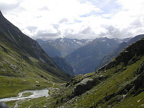
Maurertal
| Maurertal | ||
|---|---|---|
|
View out of the valley to the Lasörling group |
||
| location | East Tyrol , Austria | |
| Waters | Maurerbach | |
| Mountains | Venediger group | |
| Geographical location | 47 ° 2 '3 " N , 12 ° 18' 37" E | |
|
|
||
| height | 1400 to 2700 m above sea level A. | |
| length | 8 kilometers | |
The Maurertal in the Venediger group is together with the Umbaltal the rearmost side valley of the Virgental in East Tyrol , Austria .
It runs parallel to the Hinterbichler Dorfertal from the Isel (near Ströden ) up to the Maurer kees . The Maurerbach flows through the valley . The Stoanalm to 1464 m can be reached after a quarter of an hour from the parking lot of Ströden. Further stations on the initially densely wooded valley floor are Maureralm ( 1426 m ) and Göriacher Alm ( 1477 m ).
Below the northern end of the valley are the Essener-Rostocker Hütte , the Simonykees with the Simonysee at its foot . Of the ridge that closes the Maurertal valley in the north, the Maurertörl ( 3,104 m ) deserves special mention , especially with regard to the crossing into the province of Salzburg, which is popular with tourers .
Further mountain morphologically and touristic significant points in the Maurertal valley are the Rostocker Eck ( 2749 m ), not far from the Essen-Rostocker Hütte , the Malham peaks (heights up to 3,368 m), the Gubach peaks (heights up to 3,378 m), Westliche ( 3481 m) m ) such as the eastern Simonyspitze ( 3448 m ), the Maurerkeesköpf (highest: 3,325 m), the Great Geiger ( 3360 m ), the Great Happ ( 3352 m ) and the Türmljoch ( 2790 m ) to be passed when crossing to the Johannishütte .
Essene Rostock hut from Rostock Eck seen


