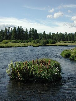
Metolius River
| Metolius River | ||
|
Map of the course of the Metolius River |
||
| Data | ||
| Water code | US : 1146118 | |
| location | Jefferson County , Oregon , USA | |
| River system | Columbia River | |
| Drain over | Deschutes → Columbia → Pacific | |
| source | at Black Butte 44 ° 25 ′ 39 ″ N , 121 ° 38 ′ 7 ″ W. |
|
| Source height | 911 m | |
| muzzle | in Lake Billy Chinook Coordinates: 44 ° 35 ′ 51 ″ N , 121 ° 17 ′ 13 ″ W 44 ° 35 ′ 51 ″ N , 121 ° 17 ′ 13 ″ W |
|
| Mouth height | 591 m | |
| Height difference | 320 m | |
| Bottom slope | 6.8 ‰ | |
| length | 47 km | |
| Drain . |
NNQ (1941) MQ HHQ (1997) |
32.48 m³ / s 43.96 63.28 |
The Metolius River is a river in the US state of Oregon . It rises in Metolius Springs on Black Butte , an extinct stratovolcano east of the town of Sisters . The river flows 29 kilometers north through the Deschutes National Forest and then turns east until it flows into Lake Billy Chinook and thus into the Deschutes River . Together with its left tributary Jefferson Creek , the lower reaches of the Metolius River forms the southern limit of the Warm Springs Indian Reservation . The river is considered to be one of the largest spring-fed rivers in Oregon.
The river and its tributaries are an important spawning area for bull trout , rainbow trout and sockeye salmon . The Metolius River is an outstanding example of a relatively pristine body of water in the Deschutes River basin and has been protected as a National Wild and Scenic River since 1988 .
A small, 12-acre area near Camp Sherman with dry meadows and primeval coniferous forest is protected by the Nature Conservancy as the Metolius River Preserve . The Deschutes Land Trust acquired a total of 500 hectares of land in the headwaters of the river near Camp Sherman in 2003, which is covered with a primeval forest of yellow pines , Douglas firs and West American larches and protects it as a Metolius Preserve . The headwaters at Camp Sherman is a popular fishing spot, especially for fly fishing .
Web links
- Deschutes & Ochoco National Forests: Metolius River
- Information from the Deschutes River Conservancy on the Metolius River
- Public Lands Information Center: Metolius River
Individual evidence
- ↑ USGS Real Time Water Data. Retrieved April 21, 2011 .
- ^ Wild and Scenic Rivers Act. (PDF; 154 kB) Retrieved April 8, 2011 .
- ^ Metolius River Preserve. (No longer available online.) Archived from the original on September 10, 2011 ; Retrieved June 7, 2011 . Info: The archive link was inserted automatically and has not yet been checked. Please check the original and archive link according to the instructions and then remove this notice.
- ^ Metolius Preserve. Archived from the original on May 1, 2012 ; Retrieved June 7, 2011 .

