
Michaelsberg (Siegburg)
| Michaelsberg | ||
|---|---|---|
 Siegburger Michaelsberg with the former Michaelsberg Abbey seen from the south-southwest from the air |
||
| height | 118.46 m above sea level NHN | |
| location | in Siegburg ; Rhein-Sieg-Kreis , North Rhine-Westphalia ( Germany ) | |
| Coordinates | 50 ° 47 '45 " N , 7 ° 12' 41" E | |
|
||
| Type | Chimney filling | |
| rock | basaltic tuff | |
| particularities | with the former Michaelsberg Abbey, the landmark of Siegburg | |

The Michaelsberg , colloquially called Michelsberg , is 118.46 m above sea level. NHN high elevation in Siegburg in the North Rhine-Westphalian Rhein-Sieg district , which rises about 55 m above the city. With its former Michaelsberg Abbey on the summit region, it is the city's landmark.
geography
location
The Michael Mountain is located east to the southeast of Siegburg downtown. From the local market , the mountain road leads up to a parking lot northwest of the summit region and then on to the former abbey. In the east, south and west to the district will Siegburg belonging survey from Siegburger Mühlengraben (channel in the river system victory bathed). In the green area with the St. John's Tower to the south of the abbey building there is a 115.4 m high point. A small part of the Siegburg-Troisdorf-Sankt Augustin landscape protection area is located on the elevation ( CDDA no. 555558590; identified in 1991; 32.5083 km² in size).
Natural allocation
The Michaelsberg belongs to the natural spatial main unit group Niederrheinische Bucht (No. 55), in the main unit Cologne Bay (551) and in the subunit Siegburger Bucht (551.0) to the natural area Sieg-Agger-Niederung (551.01) and is a natural spatial singularity of the bay. The landscape leads north in the main unit Bergische Heideterrasse (550) and in the subunit Wahner Heide (550.0) into the natural area Lohmarer Heide (550.00).
geology
The Michaelsberg, like the Wolsbergen , is a volcanic cone , which thus continues the series of volcanoes of the Eifel and the Siebengebirge . The mountains consist of basaltic tuff and have only a small amount of basalt compared to the rocks of the Siebengebirge.
history
With its single position in front of the Cologne Bay , the Michaelsberg already offered the Ezzone a location for their central castle in the Auelgau . Until the establishment of the Benedictine Abbey Michaelsberg , the elevation was called Sygberg .
The mountain area of the abbey was not under the sovereignty of the city in the Middle Ages, but was independent or subordinate to the Archbishop of Cologne . The witch's tower and the Johannistürmchen can still be found on the Michaelsberg in medieval installations.
gallery

View from 1646 after Matthäus Merian
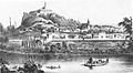
Michaelsberg around 1860
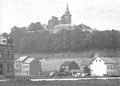
Michaelsberg penitentiary seen from Neuenhof in 1884
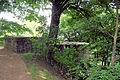
Reconstructed foundation walls of the witch tower
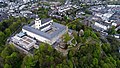
Bird's Eye View (2017)


Individual evidence
- ↑ Topographical Information Management, Cologne District Government, Department GEObasis NRW ( Notes )
- ↑ Map services of the Federal Agency for Nature Conservation ( information )
- ^ Institute for Regional Studies (ed.); Heinrich Müller-Miny (arrangement): Geographical and regional explanations for the topographical map 1: 50000 . 1. Delivery, self-published by the Federal Institute for Regional Studies and Spatial Research, Bad Godesberg 1963, p. 33.
literature
- Yearbook of the Rhein-Sieg-Kreis 2007, Edition Blattwelt, Niederhofen 2006