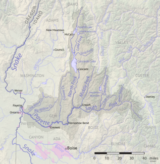
Middle Fork Payette River
| Middle Fork Payette River | ||
| Data | ||
| Water code | US : 386832 | |
| location | Boise County , Valley County in Idaho (USA) | |
| River system | Columbia River | |
| Drain over | South Fork Payette River → Payette River → Snake River → Columbia River → Pacific Ocean | |
| Headwaters |
Salmon River Mountains 44 ° 33 ′ 5 " N , 115 ° 45 ′ 51" W. |
|
| Source height | approx. 1900 m | |
| muzzle |
South Fork Payette River Coordinates: 44 ° 6 '14 " N , 116 ° 0' 3" W 44 ° 6 '14 " N , 116 ° 0' 3" W. |
|
| Mouth height | 916 m | |
| Height difference | approx. 984 m | |
| Bottom slope | approx. 15 ‰ | |
| length | 65 km | |
| Catchment area | 872 km² | |
| Discharge at the Crouch A Eo gauge : 872 km² Location: 2 km above the mouth |
MQ 2000/2016 Mq 2000/2016 |
10.5 m³ / s 12 l / (s km²) |
| Communities | Crouch | |
|
Middle Fork Payette River in the Payette River basin |
||
The Middle Fork Payette River is a right tributary of the South Fork Payette River in the east of the US state Idaho .
The river has its source in the Salmon River Mountains at an altitude of about 1900 m . The Middle Fork Payette River flows in a south-southwest direction through the mountains of the Boise National Forest and flows into the westward flowing South Fork Payette River near the village of Crouch . The 65 km long Middle Fork Payette River drains an area of 872 km². The mean discharge of the Middle Fork Payette River at the Crouch gauge is 10.5 m³ / s. May is usually the month with the greatest flow.
The course of the river is easily accessible via forest roads and is a popular fishing destination. In the river there are u. a. the following fish species: Brook trout ( Salvelinus fontinalis ), bull trout ( Salvelinus confluentus ), cutthroat trout ( Oncorhynchus clarki ), Prosopium williamsoni (Mountain Whitefish), rainbow trout ( Oncorhynchus mykiss ) and Oncorhynchus mykiss gairdneri) (Redband Trout)
Individual evidence
- ↑ Middle Fork Payette River in the Geographic Names Information System of the United States Geological Survey
- ↑ a b c d USGS 13237920 MIDDLE FORK PAYETTE RIVER NR CROUCH ID
- ^ Idaho Fishing Planner: Middle Fork Payette River . Idaho Department of Fish and Game. Retrieved October 5, 2017.

