South Fork Payette River
| South Fork Payette River | ||
|
Smith Falls on the upper reaches of the South Fork Payette River |
||
| Data | ||
| Water code | US : 390989 | |
| location | Boise County in Idaho (USA) | |
| River system | Columbia River | |
| Drain over | Payette River → Snake River → Columbia River → Pacific Ocean | |
| Headwaters |
Sawtooth Range 43 ° 57 ′ 51 ″ N , 115 ° 0 ′ 2 ″ W. |
|
| Source height | approx. 2680 m | |
| Association with |
North Fork Payette River to Payette River Coordinates: 44 ° 5 '4 " N , 116 ° 6' 55" W 44 ° 5 '4 " N , 116 ° 6' 55" W. |
|
| Mouth height | 861 m | |
| Height difference | approx. 1819 m | |
| Bottom slope | approx. 14 ‰ | |
| length | 130 km | |
| Catchment area | approx. 3100 km² | |
| Discharge at the Lowman A Eo gauge : 1155 km² |
MQ 1942/2016 Mq 1942/2016 |
24 m³ / s 20.8 l / (s km²) |
| Right tributaries | Deadwood River , Middle Fork Payette River | |
| Flowing lakes | Vernon Lake, Edna Lake, Virginia Lake | |
| Communities | Lowman | |
|
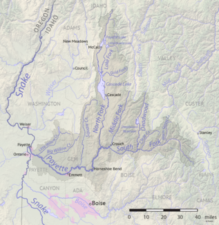
South Fork Payette River in the Payette River basin |
||
The South Fork Payette River is the left headwaters of the Payette River in the east of the US state Idaho .
The river has its origin in a nameless lake in the Sawtooth Range at an altitude of about 2680 m . On the upper reaches are the small mountain lakes Vernon Lake , Edna Lake and Virginia Lake . The South Fork Payette River initially flows 32 km northwest before turning west. The Idaho State Highway 21 , the Ponderosa Pine Scenic route runs, 37 km along the river until after Lowman . The Deadwood River flows into the river on the right side shortly afterwards. Later, the Middle Fork Payette River , also coming from the north, meets the river. This joins near Banks with the North Fork Payette River to form the Payette River. The 130 km long South Fork Payette River drains an area of approximately 3,100 km². The mean discharge of the South Fork Payette River at the Lowman gauge is 24 m³ / s. May and June are the months with the highest discharge.

