Deadwood River
| Deadwood River | ||
|
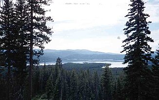
View of the Deadwood Reservoir |
||
| Data | ||
| Water code | US : 380355 | |
| location | Boise County , Valley County in Idaho (USA) | |
| River system | Columbia River | |
| Drain over | South Fork Payette River → Payette River → Snake River → Columbia River → Pacific Ocean | |
| Headwaters |
Salmon River Mountains 44 ° 32 '39 " N , 115 ° 33' 48" W. |
|
| Source height | 2124 m | |
| muzzle |
South Fork Payette River Coordinates: 44 ° 4 ′ 45 " N , 115 ° 39 ′ 30" W 44 ° 4 ′ 45 " N , 115 ° 39 ′ 30" W. |
|
| Mouth height | 1135 m | |
| Height difference | 989 m | |
| Bottom slope | approx. 14 ‰ | |
| length | approx. 70 km | |
| Catchment area | 614 km² | |
| Discharge at the gauge below Deadwood Reservoir A Eo : 282 km² Location: 36 km above the mouth |
MQ 1931/2016 Mq 1931/2016 |
6.5 m³ / s 23 l / (s km²) |
| Reservoirs flowed through | Deadwood Reservoir | |
|
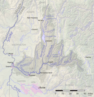
Deadwood River in the Payette River basin |
||
The Deadwood River is a right tributary of the South Fork Payette River in the east of the US state Idaho .
The river has its source in the Salmon River Mountains at an altitude of 2124 m . The Deadwood River flows south through the mountains of the Boise National Forest and flows west of the village of Lowman into the west-flowing South Fork Payette River. 36 km above the estuary, the river is dammed up by the Deadwood Dam, built between 1929 and 1931, to form the 12.9 km² Deadwood Reservoir (capacity: 190 million m³). The approximately 70 km long Deadwood River drains an area of approximately 614 km², of which 282 km² are in the catchment area of the reservoir.
In the Deadwood River system are u. a. The following fish species and genera represented: bull trout ( Salvelinus confluentus ), cutthroat trout ( Oncorhynchus clarki lewisi ), Kokanee ( Oncorhynchus nerka kennerlyi ), rainbow trout ( Oncorhynchus mykiss ), Richardsonius balteatus (Redside Shiner) Cottus (sculpin), Rhinichthys (Dace ) and Prosopium williamsoni (Mountain Whitefish).
Individual evidence
- ↑ a b c d e f g Technical Report for Idaho Department of Fish and Game Permit No. F-02-07-09: Boise and Deadwood River Bull Trout (Salvelinus confluentus) Monitoring Activities . Idaho Department of Fish and Game. January 2010. Archived from the original on December 27, 2014. Info: The archive link was automatically inserted and not yet checked. Please check the original and archive link according to the instructions and then remove this notice. Retrieved October 5, 2017.
- ^ Deadwood River in the Geographic Names Information System of the United States Geological Survey
- ↑ USGS 13236500 DEADWOOD RIVER BL DEADWOOD RES NR LOWMAN ID

