Miguel Hidalgo (Delegación)
| Miguel Hidalgo | ||
|---|---|---|

|
||
| Symbols | ||
|
||
| Basic data | ||
| Country | Mexico | |
| Capital district | Mexico city | |
| surface | 46.5 km² | |
| Residents | 372,889 (2010) | |
| density | 8,013.8 inhabitants per km² | |
| Website | miguelhidalgo.gob.mx/ | |
| INEGI no. | 09008 | |
| politics | ||
| Jefe delegacional | Xóchitl Gálvez Ruiz | |
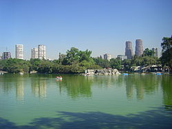
| Lake Chapultepec | ||
Coordinates: 19 ° 25 ′ 50 ″ N , 99 ° 12 ′ 30 ″ W.
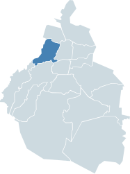
The Delegación Miguel Hidalgo , named after the initiator of the Mexican War of Independence , is one of 16 districts ( delegaciones ) in the Mexican capital, Mexico City .
Miguel Hidalgo is located west of the Cuauhtémoc district , which is the historic center of Mexico City. The splendid boulevard Paseo de la Reforma crosses both Delegaciónes and goes west at the Bosque de Chapultepec into the Delegación Miguel Hidalgo, which is one of the most expensive residential areas of the Mexican capital with the colonias Chapultepec , Lomas de Chapultepec and Polanco . In contrast to these upscale neighborhoods in the east of the district, on the other hand, Tacubaya in the west of the district is one of the poorest areas of the Mexican capital today.
Web links
- Official website of the Delegación Miguel Hidalgo (Spanish)
- Enciclopedia de los Municipios y Delegaciones de México: Delegación Miguel Hidalgo (Spanish)
- INEGI : Datos Geográficos: Delegación Miguel Hidalgo (Spanish; PDF)


