Benito Juárez (Delegación)
| Benito Juarez | ||
|---|---|---|

|
||
| Symbols | ||
|
||
| Basic data | ||
| Country | Mexico | |
| Capital district | Mexico city | |
| surface | 26.8 km² | |
| Residents | 385,439 (2010) | |
| density | 14,391.7 inhabitants per km² | |
| Website | delegacionbenitojuarez.gob.mx | |
| INEGI no. | 09014 | |
| politics | ||
| Jefe delegacional | Christian Damián From Roehrich de la Isla | |
| Polyforum Cultural Siqueiros | ||
Coordinates: 19 ° 22 ′ 46 ″ N , 99 ° 9 ′ 33 ″ W.
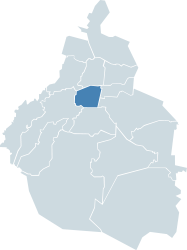
The Delegación Benito Juárez , named after the former Mexican President , is one of 16 districts ( delegaciones ) in the Mexican capital, Mexico City .
location
Benito Juárez is located south of the Delegación Cuauhtémoc , in which the historic old town is located, and north of the Coyoacán district , which includes the Ciudad Universitaria with the Estadio Olímpico Universitario and the Aztec Stadium .
Attractions
The Delegación Benito Juárez is home to the Ciudad de los Deportes, which was largely built in the 1940s, with the Estadio Azul , home of the CD Cruz Azul , and the Plaza México , the largest bullring in the world. The Colonia Nápoles of this district also houses the World Trade Center of Mexico City and the Polyforum Cultural Siqueiros with the world's largest mural La Marcha de la Humanidad by David Alfaro Siqueiros .
Population structure
The population of the Delegación Benito Juárez is largely to be assigned to the middle class or the upper middle class, making the district one of the wealthiest residential areas in Mexico. In his quarters Mixcoac and San Pedro de los Pinos , at that time still independent communities just outside of Mexico City, resulting golf clubs Mixcoac Golf Club and San Pedro Golf Club founded in 1906 the Mexico Country Club , the first country club in Mexico.
Web links
- Official website of the Delegación Benito Juárez (Spanish)
- Enciclopedia de los Municipios y Delegaciones de México: Delegación Benito Juárez (Spanish)
- INEGI : Datos Geográficos: Delegación Benito Juárez (Spanish; PDF)


