Milnathort
| Milnathort | ||
|---|---|---|
| Coordinates | 56 ° 14 ′ N , 3 ° 25 ′ W | |
|
|
||
| Residents | 1890 2011 census | |
| administration | ||
| Post town | KINROSS | |
| ZIP code section | KY13 | |
| prefix | 01577 | |
| Part of the country | Scotland | |
| Council area | Perth and Kinross | |
| British Parliament | Ochil and South Perthshire | |
| Scottish Parliament | Perthshire South and Kinross-shire | |
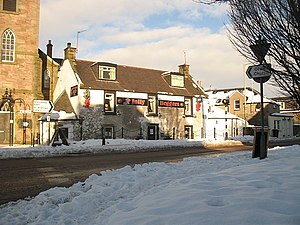
Milnathort is a town in the Scottish Council Area Perth and Kinross and the traditional county of Kinross-shire . It is located approximately 15 km west-northwest of Glenrothes and 37 km south of Perth at the foot of the Ochil Hills . Milnathort is just south of the M90 , which runs from Dunfermline to Perth, and in its extension as the A90 crosses the Firth of Forth towards Edinburgh . There is no connection to the railway network. In 2011 Milnathort had 1890 inhabitants.
history
Milnathort developed as the market town of the nearby Burleigh Castle . Between 1780 and 1828 Milnathort was the location of the Hattonburn whiskey distillery . In the early 19th century, the location at the intersection of two streets helped the village develop. In 2006, heavy rains caused the Back Burn , which flows through Milnathort, to overflow, resulting in the evacuation of part of the population.
Remains of Burleigh Castle
Main road from Kinross
Individual evidence
- ↑ 2011 census
- ↑ a b Entry in the Gazetteer for Scotland
- ↑ entry to Hattonburn distillery on lostdistillery.com
- ↑ Entry on the Hattonburn distillery on scotlandsplaces.gov.uk ( Memento of the original from February 16, 2016 in the Internet Archive ) Info: The archive link was automatically inserted and not yet checked. Please check the original and archive link according to the instructions and then remove this notice.
- ↑ BBC NEWS, Scotland, Tayside and Central: Village evacuated amid flooding , December 14, 2006


