Milwaukie
|
|
This article was on the basis of substantive defects quality assurance side of the project USA entered. Help bring the quality of this article to an acceptable level and take part in the discussion ! A closer description on the resolving issues is missing. |
| Milwaukie | ||
|---|---|---|
| Nickname : Dogwood City of the West | ||
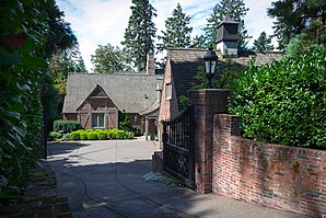
 Clarence E. Francis House |
||
| Location in Oregon | ||
|
|
||
| Basic data | ||
| Foundation : | 1903 | |
| State : | United States | |
| State : | Oregon | |
| County : | Clackamas County | |
| Coordinates : | 45 ° 27 ′ N , 122 ° 38 ′ W | |
| Time zone : | Mountain ( UTC − 7 / −6 ) | |
| Residents : | 20,841 (as of 2009) | |
| Population density : | 1,667.3 inhabitants per km 2 | |
| Area : | 12.5 km 2 (approx. 5 mi 2 ) of which 12.5 km 2 (approx. 5 mi 2 ) are land |
|
| Height : | 13 m | |
| Postcodes : | 97222, 97267, 97269 | |
| Area code : | +1 503 | |
| FIPS : | 41-48650 | |
| GNIS ID : | 1166682 | |
| Website : | www.ci.milwaukie.or.us | |
| Mayor : | Jeremy Ferguson | |
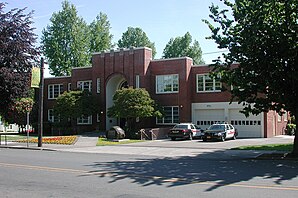
 Milwaukie City Hall |
||
Milwaukie is a city in Clackamas County in the state of Oregon in the United States . A small part of the city is in Multnomah County. In 2009 the population was 20,841. Milwaukie is a suburb of Portland .
history
The city, which is named after Milwaukee , Wisconsin, was founded in 1847 by Lot Whitcomb on the banks of the Willamette River . In the decades after it was founded, the inhabitants made their living from forestry, shipbuilding and agriculture. Originally intended as a cargo handling point and trading center for shipping on the Willamette River, Milwaukie never achieved the importance of neighboring Portland. Due to the decline in population to around 100 in 1901 and the poor general condition of the urban infrastructure, the city was officially incorporated in 1903. After the creation of a city council in 1903, the establishment of water and electricity supply and the opening of a rail link to Portland followed. From 1950, Milwaukie's population quadrupled as many people working in Portland moved to the suburbs.
The National Park Service has six houses for Milwaukie on the National Register of Historic Places (NRHP) as of December 27, 2018, including the Clarence E. Francis House .
Web links
- Official site of the City (English)
Individual evidence
- ↑ Milwaukie City, Oregon . US census bureau. Retrieved March 23, 2011.
- ↑ Milwaukie History Series # 1 - Downtown development patterns (PDF; 2.7 MB) ci.milwaukie.or.us. Retrieved on March 24, 2011. ( Page no longer available , search in web archives ) Info: The link was automatically marked as defective. Please check the link according to the instructions and then remove this notice.
- ↑ Search mask database in the National Register Information System. National Park Service , accessed December 27, 2018.

