Mohican River
| Mohican River | ||
|
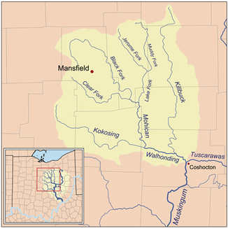
The Mohican River and tributaries within the Walhonding River basin. |
||
| Data | ||
| Water code | US : 1066841 | |
| location | Central State of Ohio , USA | |
| River system | Mississippi River | |
| Drain over | Walhonding River → Muskingum River → Ohio River → Mississippi River → Gulf of Mexico | |
| origin | The confluence of the Black Fork and Clear Fork at Loudonville, Ashland County, Ohio 40 ° 36 ′ 29 ″ N , 82 ° 15 ′ 14 ″ W |
|
| Source height | 281 m | |
| muzzle | forms the Walhonding River in western Coshocton County by confluence with the Kokosing River Coordinates: 40 ° 21 ′ 36 ″ N , 82 ° 9 ′ 37 ″ W 40 ° 21 ′ 36 ″ N , 82 ° 9 ′ 37 ″ W |
|
| Mouth height | 250 m | |
| Height difference | 31 m | |
| Bottom slope | 0.48 ‰ | |
| length | 64 km | |
| Catchment area | 2587 km² | |
The Mohican River is a 40 mile long river in the central US state of Ohio . Outflow is via the Walhonding , Muskingum , Ohio and Mississippi Rivers into the Gulf of Mexico . It belongs to the Mississippi river system and drains an area of around 1,248 km². The two source rivers Black Fork and Clear Fork form 3 km southwest of the village of Loudonville in Ashland County by union of the Mohican River. After about 8 km it takes the Lake Fork Mohican River coming from the north and flows meandering in a southerly direction through western Holmes County and northeastern Knox County . 3 km northwest of the village of Nellie in northwestern Coshocton County , it meets the Kokosing River and both rivers form the Walhonding River here. At Brinkhaven, the river is spanned by the Bridge of Dreams . This bridge is the longest covered wooden bridge in Ohio at around 114 m . According to the Geographic Names Information System , the river has also been referred to as Margrets Creek, Mohican John Creek, Mohiccon Creek, Mohickin Johns River and similar names in its settlement history.
Individual evidence
- ↑ a b Google Earth altitude for GNIS coordinates, accessed on July 23, 2010.
- ↑ a b c d Mohican River in the Geographic Names Information System of the United States Geological Survey
- ^ Bridge of Dreams , accessed July 23, 2010

