Kokosing River
| Kokosing River | ||
|
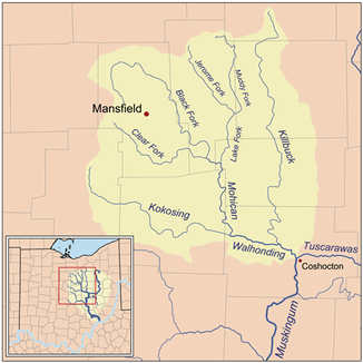
The Kokosing River within the Walhonding River basin. |
||
| Data | ||
| Water code | US : 1056385 | |
| location | Central State of Ohio, USA | |
| River system | Mississippi River | |
| Drain over | Walhonding River → Muskingum River → Ohio River → Mississippi River → Gulf of Mexico | |
| origin | at Shauck in Morrow County, Ohio 40 ° 35 ′ 6 " N , 82 ° 42 ′ 55" W. |
|
| Source height | 425 m | |
| muzzle | forms the Walhonding River in western Coshocton County by confluence with the Mohican River Coordinates: 40 ° 21 ′ 36 ″ N , 82 ° 9 ′ 37 ″ W 40 ° 21 ′ 36 ″ N , 82 ° 9 ′ 37 ″ W |
|
| Mouth height | 250 m | |
| Height difference | 175 m | |
| Bottom slope | 1.9 ‰ | |
| length | 92 km | |
| Catchment area | 1248 km² | |
The Kokosing River is a 92 km long tributary of the Walhonding River in the central US state of Ohio . About the Walhonding, Muskingum and Ohio Rivers it belongs to the river system of the Mississippi River and drains an area of around 1,248 km². The Kokosing River has its source in Morrow County northeast of Mount Gilead and initially flows south. At the town of Chesterville he turns east and crosses Knox and Coshocton Counties, touching the towns of Mount Vernon , Howard and Gambier. 3 km northwest of the village of Nellie in northwestern Coshocton County it meets the Mohican River and both rivers form the Walhonding River. Above Mount Vernon, the Kokosing River takes its most important tributary, the North Branch Kokosing River coming from the northwest (northern arm of the Kokosing River). According to the Geographic Names Information System , the river has also been referred to as Kokoshing River, Owl Creek, Vernon River, and similar names in its settlement history.
Two mounds near the city of Fredericksburg testify to the presumably first settlers on the Kokosing River . In the 18th and 19th centuries, the area was used as hunting ground by several Indian tribes, including the Shawnee , Wyandot, and Delaware . There were larger Indian villages further downstream on the Walhonding River. After the Treaty of Greenville of 1795, most of the Indians had to leave the area and around 1803 new settlements of white immigrants emerged. Sawmills and grain mills powered by water power were built on the river, and the Kokosing River was used as a transport route for wood and agricultural products. Increasing deforestation and the associated soil erosion changed the hydrology of the river, so the mills had to be closed and commercial boat operations had to be stopped.
Between Mount Vernon and Howard, the river is accompanied by the Kokosing Gap Trail . This paved hiking and biking trail was laid out on the former Pennsylvania Railroad line between Mount Vernon and Danville.
Individual evidence
- ↑ a b Google Earth altitude for GNIS coordinates, accessed on July 23, 2010.
- ↑ a b c Kokosing River in the Geographic Names Information System of the United States Geological Survey
- ↑ Facts about the Kokosing River , accessed July 23, 2010
- ^ Kokosing Gap Trail , accessed July 23, 2010

