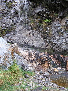
Moine Thrust
Moine Thrust is a geological ceiling - thrust in the north of Scotland . It is about 180 km long and extends from the south of the Isle of Skye to Loch Eriboll in northeast Sutherland . The name is derived from a'Mhoine , the name for moor in North Sutherland.

The Moine Thrust was formed 410 to 430 million years ago during the Caledonian mountain formation by the thrust from the European to the American crust . The thrust zone is several kilometers wide and separates a tectonically recognizable stressed metamorphic gneiss ( Lewisian gneiss ) from the overlying sediments of the neoproterozoic Moine Supergroup in the southeast from the neoproterozoic and Cambrian - Ordovician rocks in the northwest.
The Moine Thrust was identified as the first thrust belt in 1907.
In the Geopark Knockan Crag , about 20 km north of Ullapool , the thrust can be viewed in a geological outcrop . A small visitor center offers an overview of the geological situation, short circular hiking trails lead to the outcrop.
Web links
- Rob Butler: The Moine Thrust Belt: an introduction to the most important sites. School of Earth Sciences, University of Leeds (English)
- Description of the geology of the Northwest Highlands including Moine Thrust at www.scottishgeology.com (English)
Individual evidence
- ^ RJ Howarth & BE Leake: The life of Frank Coles Phillips (1902-1982) and the Structural Geology of the Moine Petrofabric Controversy . In: Geological Society London Memoir . tape 23 , 2002 ( online ).
- ^ John Horne , William Gunn, Charles Thomas Clough , Jethro Justinian Harris Teall & Lionel Wordsworth Hinxman : The geological structure of the North-West Highlands of Scotland . (Memoirs of the Geological Survey of Great Britain), James Hedderwick & sons, Glasgow 1907, p. 653 ( online in the library of the BGS )
