Skye
| Skye | |
|---|---|
| Map of Skye | |
| Waters | Scottish Sea |
| Archipelago | Inner Hebrides |
| Geographical location | 57 ° 20 ′ N , 6 ° 15 ′ W |
| length | 80 km |
| width | 40 km |
| surface | 1 656 km² |
| Highest elevation |
Sgurr Alasdair 993 m |
| Residents | 10,008 (2011) 6 inhabitants / km² |
| main place | Portree |

Skye [ skaɪ̯ ] ( English also Isle of Skye , Scottish Gaelic An t-Eilean Sgitheanach , also Eilean a 'Cheò , German island of the fog ) is the largest island in the Inner Hebrides . It is located just off the west coast of mainland Scotland in the Atlantic.
geography
Skye has an area of 1,656 km², a north-south extension of 80 kilometers and a width of 11 to 40 kilometers. The population of Skye was 10,008 in 2011, around 30 percent of whom speak Scottish Gaelic.
Skye is separated from mainland Scotland by the Sound of Sleat, Kyle Rhea and Kyle Akin (also Loch Alsh). The Little Minch separates Skye from the Outer Hebrides . Off the east coast are the islands of Rona , Raasay , Scalpay and Pabay . To the south, separated by Soay Sound, is Soay Island . The coastline of the island is heavily indented. So-called lochs and other bays reach so deep into the hinterland that no point on the island is further than eight kilometers from the sea. This creates five larger peninsulas: Sleat in the south, Minginish in the southwest, Duirinish in the northwest, Waternish or Vaternish in the north-northwest and Trotternish in the north. The highest point in a mountainous terrain is the 993 meter high Sgùrr Alasdair in the rough Black Cuillins , which is also the highest point in the entire Hebrides .
Administrative division
The capital of the island is Portree . Other locations include Ardvasar , Armadale , Broadford , Dunvegan , Elgol , Isleornsay , Kyleakin , Skeabost , Staffin and Uig . The island belongs to the traditional county of Inverness-shire . The Skye and Lochalsh District is one of the eight administrative units of the Highland Council . On the island itself, seven civil parishes (such as parish districts) are identified, which also extend to the aforementioned secondary islands:
| Kilmuir 139 km² (with staff ) |
| Snizort 216 km² (with Skeabost , Uig ) |
| Duirinish 324 km² (with Dunvegan ) |
| Portree 230 km² |
| Bracadale 377 km² |
| Strath 282 km² (with Broadford , Elgol , Kyleakin ) |
| Sleat 168 km² (with Ardvasar , Armadale , Isleornsay ) |
| Small Isles Parish |
In general usage, the geographical division based on the traditional peninsulas is more common, which only partially coincides with the administrative structure.
Sleat
Sleat (Scottish Gaelic: Sléibhte or Slèite ) is a peninsula in the south of Skye. It is separated from the mainland by the Sound of Sleat . The original Scottish Gaelic name means something like "plain", but this does not correspond to the topographical reality. The peninsula, which is also known as the "Skyes Garden", is mainly characterized by gently undulating, hilly landscapes. Only in comparison to the northern mountains of the Black Cuillins does Sleat appear relatively flat. Sleat is a stronghold of the Scottish Gaelic language. About 40 percent of the population speak this language. Accordingly, the Gaelic-speaking college Sabhal Mòr Ostaig , which belongs to the University of the Highlands and Islands , is located on the peninsula .
On Sleat is the former clan seat of the MacDonalds , the Armadale Castle , which today is mostly only a ruin. In the neighboring building of the ruin, the clan history of the Lords of the Isles is presented in the Visitors Center . This includes an old park with tree species that are otherwise found in North America. Their growth is favored by the mild climate, which is influenced by the Gulf Stream .
Duirinish
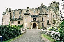
Duirinish in the north-west of the island has Dunvegan, the main town on the western coastline. From Dunvegan, various single lane back roads lead further into the coastal landscape around Loch Dunvegan and over the ridge of the peninsula to the northwest coast. The area around Dunvegan and Glendale, which is traditionally characterized by crofting , has seen a particularly strong influx of mainland Britons and the associated renovation or new construction of holiday homes since 1990. High above Loch Dunvegan is Dunvegan Castle , ancestral home of the MacLeods for over 800 years . It is believed to be the UK's oldest privately owned inhabited castle. Below Dunvegan Castle there is the option of a boat tour to some seal rocks . Above the opposite bank of the hole is Borreraig, the ancestral home of the MacCrimmons, the traditional bagpipers of the MacLeods. Their story is told in the Borreraig Park Museum , which also contains numerous exhibits of traditional agricultural and often difficult life. The Colbost Croft Museum in Colbost, where a traditional Black House can be visited, is dedicated to the same topic . The Three Chimneys Restaurant in the same location has won multiple awards and even attracts its customers from major cities on the British mainland that are more than a day's journey away. Other museums with a more specific theme include the Giant Angus MacAskill Museum in Dunvegan and the Toy Museum in Glendale.
A few kilometers west of Dunvegan is the Neist peninsula with Neist Point as the westernmost point on the island. There is a lighthouse there that is in operation. The adjacent bay is dominated by Waterstein Head (296 meters) and partly vertical cliffs including a small waterfall that falls directly into the sea. Sometimes you can spot whales, dolphins and seals here.
Minginish
Minginish in the south-west of Skye includes the Black Cuillins, the highest mountain range on Skye, which shows all hues from gray to deep black. The highest mountain is the 993 meter high Sgùrr Alasdair . From the fishing village of Elgol you can see the mountain range well. From there, boat tours near the Cuillins are possible. Within the Black Cuillins is Loch Coruisk , which is considered one of the most remote lakes in Great Britain. On the outskirts of Carbost is located Talisker -Destillerie, the only Single Malt Whiskey - distillery on Skye. The Talisker whiskey is known for its intense aroma with a peat note. Talisker is also an integral part of the well-known whiskey brand Johnnie Walker .
Waternish
Waternish, also known as Vaternish, is a smaller peninsula in northwest Skye. The most famous place of Waternish is Trumpan.
Trotternish
The Storr; right of the summit: The Old Man of Storr
View from Quiraing to Staffin Bay
The Old Man of Storr , a 50 meter high rock needle, is located here, as is the Quiraing . It lies on the east side of the northernmost summit of Trotternish. The landscape was created by a landslide; the terrain is still unstable. The Skye Museum of Island Life in Kilmuir on the northern end of the peninsula shows how the people of Skye lived. This includes exhibits about houses - the Black Houses - work, religion, poverty and emigration as well as reconstructions and originals of huts and equipment. Flora MacDonald's grave lies in Kilmuir's cemetery . Uig is the starting point for the Caledonian MacBrayne ferry route to the Outer Hebrides. On the east coast is Loch Mealt , which flows in a waterfall over the cliffs into the Scottish Sea.
story
Skye has been settled for a long time. The missionary Columban , coming from Iona , visited the island twice in the 6th century . The hole Chaluim Chille (German: Bay Columbanus) found a monastery in the north of the island on which tracks should have been his landing site.
Shortly after 800 Vikings and Norwegian settlers invaded Skye. There was looting and devastation. The distribution of Viking finds and place names on Skye indicates that the settlers occupied the southern part of the island and left the north to the Picts . Over time, the groups became mixed up.
In the 1090s, the MacLeod clan , who were of Norwegian origin, ruled Skye. The Norwegian King Magnus III. led a campaign against the clan to secure its influence. Once again there was devastation. In 1156, the half-Gaelic, half-Norwegian Somerled of Argyll defeated the Norwegians and established the rule of the MacDonald clan over Skye and other Hebridean islands. They were called Lords of The Isles . The Norwegian King Håkon IV tried to retake Skye and other areas, but failed and died on the way back in the Orkneys . In 1266 all Norwegian possessions in the Hebrides were given to Alexander III. transfer. The Lords of the Isles disregarded this until 1493, when they were ousted by the Scottish King James IV .
In 1549 Donald Monro wrote a report on the Hebrides, A Description of the Western Isles of Scotland called Hybrides . Skye was detailed in this report.
In the 18th century there were several attempts to restore the rule of the Stuart Line, including in 1715 and 1745. The participants in these revolts were called Jacobites . The latter attempt ended in the Battle of Culloden , lost by the heir to the throne Charles Edward Stuart , known as Bonnie Prince Charlie . On the run from the Duke of Cumberland's troops , with the help of the islander Flora MacDonald, he came in a rowboat from North Uist to Skye, from where he was able to flee to France. Even today, the folk song Skye Boat Song , which is based on it, is popular in the English-speaking world.
Until 1830, seaweed harvest was a major source of income for the island. The kelp obtained by burning the kelp was used to produce soap, bleach and materials for making glass. After other raw materials had replaced the kelp, a period of economic decline began. During this time, sheep breeding gained in importance.
Around 30,000 residents left the island between 1840 and 1883. 6940 farms were closed during this time. In 1849 about 5000 islanders were dependent on food aid. In 1854, Suishnish was the site of Highland Clearances on Skye . Numerous crofters , i.e. tenants, were driven from their lands and were forcibly relocated to Canada or other overseas territories. This great bloodletting weakened Gaelic culture on Skye. The reason for the evictions was the desire of the Lairds (for example: feudal landowners) to intensify sheep farming.
In 1882 the Battle of the Braes (German: Battle of Braes) took place. Farmers in the Braes district near Portree attacked 50 police officers seconded from Glasgow to maintain order . The trigger was a dispute over grazing rights. This skirmish is considered the last battle on British soil to date. In 1886 the protests of the Crofters resulted in the Crofters' Holdings Act (German for example: Crofter leasing law). At the time, these farmers in Scotland were given more rights. The Crofter system still exists on Skye today.
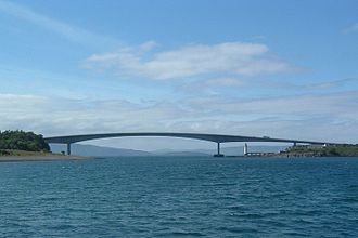
In 1897 the railway line was completed on the Scottish mainland to the ferry terminal Kyle of Lochalsh . This led to an economic boom on Skye. The construction of the Skye Bridge , which opened in 1995, also had a lasting impact on the economy and tourism . Since then, Skye has had a permanent connection to the mainland and traffic no longer relies on ferries .
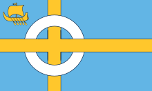
After Skye had various unofficial flags in the past, "Bratach an Eilein" ("the flag of Skye") has been the official flag of the island since it was approved by the Lord Lyon King of Arms in August 2020. This decision was preceded by a competition in which 369 proposals were submitted. Over 7,000 votes were cast, and in the end the proposal of nine-year-old Calum Alasdair Munro from Kilmuir in the north of the island prevailed. Munro collects flags and has incorporated the history of the Celts , the Vikings and Flora MacDonald into his proposal , which is closely linked to the Isle of Skye. The Birlinn in Upper Liek is a medieval ship from the Hebrides and western Scotland area. The Birlinn's five oars symbolize the five regions of Skye: Trotternish, Waternish, Duirinish, Minginish and Sleat. The colors refer to the island's clans, the yellow to the MacLeods and the blue to the MacDonalds and MacKinnons .
Prehistoric objects
There are several well-preserved brochs (listed below as Duns ) and the remains of twelve cairns on Skye . A hill fort as well as menhirs , Pictish symbol stones , basements such as Kilvaxter , stone circles and rows of stones are also among the legacies from prehistoric times. These were also found in caves such as the High Pasture Cave (Scottish Gaelic: Uamh an Ard Achadh ) near Kilbride, which has parallels with Minehowe on Orkney. Most of these places are still considered "holy places" to this day.
- Clach Ard , Pictish symbol stone near Portree
- Dun Ardtreck , Semi-Broch at Carbost
- Dun Beag , Broch at Bracadale
- Dun Fiadhairt , Broch at Dunvegan
- Dun Hallin , Broch on Waternish
- Dun Ringill , Semi-Broch at Kirkbost
- Rubh 'to Dunain , Cairn at Loch Brittle
In 2003 excavations began in the High Pasture Cave . Over 300 objects have been recovered so far. These included not only Flint, but also the typical Neolithic artifact fragments such as processed antler pins and bone tools. Most of the finds, however, date from the Iron Age and consisted of copper and copper alloys, as well as iron fragments. In 2009 a burial ground was excavated near Armadale Pier.
In 2018, the discovery of fifty dinosaur footprints, 170 million years old, made by sauropods and theropods , was announced.
Economy and Transport
economy
The main sources of income on Skye are tourism , agriculture , fishing and the production of whiskey .
traffic
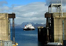
There is a road link to the mainland on the A87 over the Skye Bridge from Kyleakin to Kyle of Lochalsh. Further connections to the mainland exist with ferries from Armadale to Mallaig and from Kylerhea to Glenelg (not served in 2007, operations resumed in 2008 with the " Glenachulish "). Further ferry operations take place from Uig to Tarbert on Harris and to Lochmaddy on North Uist and from Sconser to Inverarish on Raasay . There are no railways on Skye, but the island can be reached by rail via the west coast terminus Kyle of Lochalsh and Mallaig with connections to Inverness and Fort William / Glasgow. Skye does not have an airfield, although there have been plans for this again and again and there is a small airstrip at Broadford which, however, has not had an operating license since 1989.
On Skye there is a public bus service between the main towns of the various peninsulas and Portree. In the past, these routes were operated by the so-called post buses. The connections are now publicly tendered; The company Stagecoach held the operating license for the lines on Skye in 2010 . The departure times are mostly coordinated with the connections for the ferry or train departures and / or school times. Taxi services, tour operators and car rental companies complement the local mobility offer. There are direct connections to Glasgow by long-distance buses .
Personalities
- Flora MacDonald (1722–1790), helped the Scottish pretender Charles Edward Stuart to escape
- Mary MacPherson (1821–1898), Scottish Gaelic Màiri Mhòr nan Oran called, German "The great Mary of songs"; Scottish Gaelic patriot, poet and songwriter
- Donnie Munro (* 1953), folk singer , was born in Uig on Skye
- Mylo (* 1978), House -DJ, was born on Skye
- Danny MacAskill (* 1985), professional bike trial , was born on Skye
literature
- James Hunter: Skye. The Island. Photographs Cailean Maclean. Mainstream Publishing, Edinburgh 1986, ISBN 1-85158-017-4 .
- Norman Newton: Skye. David & Charles, Newton Abbot 1995, ISBN 0-907115-89-6 .
Web links
- Official website (English)
Individual evidence
- ↑ 2011 census data
- ^ Three Chimneys Restaurant website, Awards
- ↑ Nine-year-old Calum raises first-ever flag for Skye at official ceremony on whfp.com, accessed September 1, 2020
- ↑ Information on the grave field , accessed on June 30, 2010
- ↑ 170 million year old dinosaur footprints discovered. tagesspiegel.de , April 4, 2018, accessed on July 16, 2020 .


