Scottish Sea
Coordinates: 56 ° 0 ′ 0 ″ N , 7 ° 0 ′ 0 ″ W.
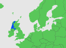
The Scottish Sea is the term used by hydrographers to refer to the marine area between the north coast of Ireland , Scotland , and the Outer Hebrides in the northwest.
Demarcation
At the International Hydrographic Organization this area is called Inner Seas to the West Coast of Scotland or Scottish Seas and is separated as follows:
- To the north and west, a line from Bloody Foreland ( 55 ° 10 ′ 0 ″ N , 8 ° 17 ′ 0 ″ W ) in Ireland to the western tip of Toraigh ⊙ , on to Barra Head , the most south-westerly point of the Hebrides , then through these islands such that the west coasts of the main islands belong to the North Atlantic and all straits to the Inner Seas , up to the Butt of Lewis (northern tip), and then to Cape Wrath ( 58 ° 37'N ) in Scotland.
- To the south, a line connecting the south end of the Mull of Galloway ( 54 ° 38'N ) in Scotland and Ballyquintin Point ( 54 ° 20'N ) in Ireland .
Larger sub-waters are The Minch , The Little Minch , the Hebridean Sea , Firth of Clyde , Firth of Lorn , Jura Sound and North Channel . It is bordered by the North Atlantic to the north and west and the Irish Sea to the south .
The area of the Scottish Sea is 43,940 km². The greatest depth of 260 m is found in a trench 15 km east of Barra Head .
Flora and fauna
In 2003, about 13 kilometers west of was Mingulay m to 190 m to 120 depth a reef of cold water coral Lophelia pertusa discovered.
German shipping law
The Scottish Sea as a whole is within the scope of the German Sportseeschifferschein .
Individual evidence
- ^ Federal Maritime and Hydrographic Agency, Hamburg / Rostock, tide tables European waters. 2015, pp. 192/193, 195, 228.
- ^ Deutsches Hydrographisches Institut Hamburg, Nautical Chart No. 809: Scottish Sea - Scottish Coast - Firth of Clyde and Kyles of Bute. 5th edition. 1979, X.
- ^ Limits of Oceans and Seas, 3rd edition. (PDF) International Hydrographic Organization, 1953, accessed February 6, 2010 .
- ↑ IHO Marine Regions. (No longer available online.) Department of Human Geography, University of Seville, archived from the original on December 15, 2014 ; accessed on December 14, 2014 .
- ^ (British) Admiralty Chart 2635 Scotland - West Coast, 1: 500000. 1996.
- ↑ JM Roberts, AJ Davies, LA Henry, LA Dodds et al .: Mingulay reef complex: an interdisciplinary study of cold-water coral habitat, hydrography and biodiversity. In: Mar Ecol Prog Ser. 397, 2009, pp. 139-151.


