Molbitz (Rositz)
|
Molbitz
community Rositz
Coordinates: 51 ° 0 ′ 46 ″ N , 12 ° 24 ′ 26 ″ E
|
||
|---|---|---|
| Height : | 168-185 m above sea level NHN | |
| Area : | 3.17 km² | |
| Residents : | 150 | |
| Population density : | 47 inhabitants / km² | |
| Incorporation : | 1st January 1973 | |
| Postal code : | 04617 | |
| Area code : | 03447 | |
|
Location of Molbitz in Thuringia |
||
|
Panorama of the whole place
|
||
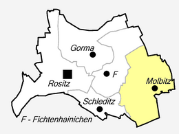
Molbitz is a district of Rositz in the east Thuringian Altenburger Land 4 km northwest of the district town Altenburg . The place emerged in 1950 from the merger of Upper and Lower Molbitz .
geography
The place is located in the Gerstenbachtal in the middle of fields in the Altenburg-Zeitzer Loesshügelland . Adjacent places are the Altenburg districts of Rautenberg , starting clockwise in the north, Oberzetzscha in the east, the Altenburg district of Zschernitzsch in the southeast, Oberlödla in the south and Rositz in the west.
history
To the north-west of Molbitz between the village and Rositz, archaeological excavations have unearthed a Neolithic settlement with around 150 homes, which is one of the largest prehistoric settlement finds in the Altenburger Land. Molbitz was first mentioned as Maluwiz from 1181 to 1214. Two spatially separated places arose, so that in 1445 Obermolbitz Mallewicz superior and Untermolbitz Mallewicz inferior . Both places were parish to Zschernitzsch . The school was also there.
During the Second World War, both places were badly damaged by their proximity to the DEA mineral oil works . Air defense was stationed around the place . The first bomb detonated in Obermolbitz in October 1940. A devastating air raid on the plant took place on August 16, 1944. The heaviest air raid occurred on February 14, 1945 around 9 o'clock in the evening. A total of around 320 bombs fell on Upper and Lower Molbitz alone, killing 14 people. The underground shaft of the Altenburg coal works served as air raid shelter . That night every residential building in the two places was damaged, numerous bomb craters enclosed the places.
On July 1, 1950, Upper and Lower Molbitz were merged to form the municipality of Molbitz. The BSG activist was founded. In 1956 a state kindergarten was established. The grocery store, which opened before the turn of the century, became a consumption that moved to the Untermolbitz inn in 1965 due to a lack of space. In the 1960s, the last farmers of the LPG type III came to an agreement . A community center with a restaurant and bowling alley was built in the Altenburg coal works, which have now been closed. Untermolbitz had a village pond, but it dried up because there was no longer any need for water from industry. Molbitz was incorporated into the Rositz community on January 1, 1973.
Today the district road maintenance department of the Altenburger Land district is located in Obermolbitz .
In the 1980s, it was planned to resume lignite mining in the Meuselwitz-Rositzer lignite district, but this was not carried out. A large part of the municipality of Rositz, including part of Molbitz, should have given way to the planned “Meuselwitz opencast mine” between Meuselwitz and Rositz.
Obermolbitz
In the 15th century Obermolbitz consisted of four farms . In 1841, 53 people lived in the village. At the end of the 19th century there were three lignite mines on Obermolbitzer Flur alone, the most famous being the Annagrube (between Molbitz and Oberlödla). In 1910 97 people lived in the village, in 1933 106, eight less than six years later. From June 19, 1872 to December 14, 2002, Obermolbitz had a stop on the Zeitz – Altenburg railway line . Obermolbitz had a population of 97 in 2012.
Lower Molbitz
Untermolbitz consisted of five farms in the 15th century. In the former dead end village there lived 93 inhabitants in 1841, in 1880 there were already 156. There was a church in the village, which was rebuilt in 1518. In 1831 it was so dilapidated that it was demolished. The population of Untermolbitz was significantly higher than that of Obermolbitz, with 246 in 1910, 446 in 1933 and 486 in 1939. There was an inn in the village, which was reopened in November 1945 after the effects of the war.
With industrialization in the second half of the 19th century, the place turned into a mining village, the pond and eastern settlements were built. Pit number 20 was already in operation around 1870 and bought by a Leipzig company in 1890. These Altenburger coal works were acquired by Rositzer Braunkohlenwerke AG in 1905 and built a new briquette factory in the 1920s. Lignite mining reached its peak after the First World War. With the charring of the Neue Sorge , the former tar lake , in 1932 a cable car was built between DEA and the coal works. In the 1960s these stopped their production.
religion
The Lutherans of the place belong to the parish Altenburg-Zschernitzsch in the parish of Altenburger Land of the Evangelical Church in Central Germany . The parish of the Mother of God from Mount Carmel in Rositz is responsible for the Catholics and belongs to the deanery of Gera in the diocese of Dresden-Meißen .
traffic
District road 223 runs through Molbitz. Between 1899 and 2002, Molbitz had a stop on the Zeitz – Altenburg railway line .
Personalities
- Edgar Braun (born June 9, 1939) - Major General of the Ministry for State Security
Individual evidence
- ↑ The Altenburg / Meuselwitz lignite district, LMBV publication
- ↑ a b gemeindeververzeichnis.de
- ^ A b Michael Rademacher: German administrative history from the unification of the empire in 1871 to the reunification in 1990. altenburg.html. (Online material for the dissertation, Osnabrück 2006).


