Lower Molbitz
|
Lower Molbitz
community Molbitz
Coordinates: 51 ° 0 ′ 46 ″ N , 12 ° 24 ′ 32 ″ E
|
||
|---|---|---|
| Height : | 173 m above sea level NN | |
| Incorporation : | July 1, 1950 | |
| Postal code : | 04617 | |
| Area code : | 034498 | |
|
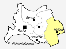
Location of Untermolbitz in Thuringia |
||
|
View of the local situation
|
||
Untermolbitz is a locality of Molbitz , a district of Rositz in the Altenburger Land district in Thuringia .
location
Untermolbitz is located southeast of Rositz and northeast of Altenburg in the Altenburger-Zeitz loess hill country and on the edge of the Leipzig lowland bay in a fertile arable area. The federal highway 180 passes close by. District road 223 runs through the village. Within the village of Molbitz, Untermolbitz is east of Obermolbitz.
history
In 1336 the village of Molbitz was first mentioned as Maluwicz . Since 1445 a distinction has been made between Obermolbitz ( Mallewicz superior ) and Untermolbitz ( Mallewicz inferior ). Both places were parish to Zschernitzsch . In the 15th century the place Untermolbitz had five farms . It was therefore somewhat larger than Obermolbitz. Small and medium-sized farmers dominated the village, while large farmers lived in Obermolbitz.
Untermolbitz belonged to the Wettin office of Altenburg , which was under the sovereignty of the following Ernestine duchies from the 16th century due to several divisions in the course of its existence : Duchy of Saxony (1554 to 1572), Duchy of Saxony-Weimar (1572 to 1603), Duchy of Saxony-Altenburg (1603 to 1672), Duchy of Saxony-Gotha-Altenburg (1672 to 1826). When the Ernestine duchies were reorganized in 1826, the place came back to the duchy of Saxony-Altenburg. The small church from 1518 had to be demolished in 1831 due to dilapidation. Since then, the Lower and Upper Molbitz people have been going to church in Zschernitzsch. After the administrative reform in the Duchy of Saxony-Altenburg, Untermolbitz belonged to the Eastern District (until 1900) and to the Altenburg District Office (from 1900). From 1918 the village belonged to the Free State of Saxony-Altenburg , which was added to the State of Thuringia in 1920. In 1922 it came to the district of Altenburg .
Unermolbitz is located in the east of the Meuselwitz-Altenburg lignite mining area . The brown coal mine number 20 on Untermolbitzer Flur was already in operation around 1870. In 1890 the purchase was made by a Leipzig company. A short time later it went to Altenburger Kohlenwerke, which was acquired in 1905 by Rositzer Braunkohlenwerke AG . They built a new briquette factory in the 1920s. As a result of industrialization and lignite mining, Untermolbitz was transformed into a mining village in the second half of the 19th century. As a result, the pond and eastern settlements emerged as settlements for the miners. The neighboring town of Obermolbitz had a stop on the Zeitz – Altenburg railway from June 19, 1872 to December 14, 2002 . In the opencast mine , the coal was mined near Untermolbitz in the Germania No. 16 opencast mine (1908 to 1919). After the First World War, lignite mining around Untermolbitz reached its peak. With the carbonization of the Neue Sorge , the former tar lake , in 1932, a cable car was built between DEA mineral oil works in Rositz and the coal works. In the 1960s these stopped their production.
During the Second World War, Upper and Lower Molbitz were badly damaged by the proximity to the DEA mineral oil works in Rositz. Air defense was stationed around the places . The first bomb detonated in Obermolbitz in October 1940. A devastating air raid on the plant took place on August 16, 1944. The heaviest air raid occurred on February 14, 1945 around 9 o'clock in the evening. A total of around 320 bombs fell on Upper and Lower Molbitz alone, killing 14 people. The underground shaft of the Altenburg coal works served as air raid shelter . That night every residential building in the two places was damaged, numerous bomb craters enclosed the places.
On July 1, 1950, Upper and Lower Molbitz were combined to form the municipality of Molbitz. On January 1, 1973, Molbitz was incorporated into Rositz. (History of the united place in the main article: Molbitz (Rositz) )
Personalities
- Sabine Fache (born March 17, 1946 in Untermolbitz), German politician (Die Linke)
Individual evidence
- ^ Wolfgang Kahl: First mention of Thuringian towns and villages. A manual. Verlag Rockstuhl, Bad Langensalza, 2010, ISBN 978-3-86777-202-0 , p. 294
- ^ History of Molbitz on the Rositz website
- ^ The Altenburg Office in the book "Geography for all Stands", from p. 201
- ↑ The locations of the Altenburg district from p.83 ,
- ↑ The eastern district of the Duchy of Saxony-Altenburg in the municipal directory 1900
- ^ The Altenburg district office in the municipality register 1900
- ↑ Description of the Meuselwitz-Altenburger brown coal area in a PDF document from the LMBV


