Mont Gelé (Chanrion)
| Mont Gelé | ||
|---|---|---|
|
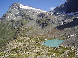
Southwest side with the Glacier du Mont Gelé from the Regondi bivouac , in the foreground the Lac de la Besèya ( 2513 m slm ) |
||
| height | 3518.2 m above sea level M. | |
| location | Border canton Valais , Switzerland / Province Aosta , Italy | |
| Mountains | Valais Alps | |
| Dominance | 4.5 km → Bec d'Epicoune | |
| Notch height | 619 m ↓ Col de Crête Sèche | |
| Coordinates , ( CH ) | 45 ° 54 '15 " N , 7 ° 21' 58" O ( 594 369 / 83613 ) | |
|
|
||
| Normal way | from the southeast or southwest over the Glacier du Mont Gelé | |
The Mont Gelé is a 3518 m above sea level. M. high mountain in the Valais Alps on the southern border of the Valais municipality of Bagnes to the Italian municipality of Ollomont in the province of Aosta .
Location and surroundings
Mont Gelé is located in the main ridge of the Valais Alps between Mont Avril ( 3347 m ) in the north-west, from which it is separated by the Fenêtre de Durand pass ( 2797 m ), and the Bec du Chardoney ( 3447 m ) and Bec d 'Epicoune ( 3531 m ), separated by the Col de Crête Sèche pass ( 2899 m ). Well-known crossings from Valais to the Aosta Valley, marked in the snow-free areas, lead over both passes. The south-eastern pre-summit of Mont Gelé is called Mont de la Balme and reaches a height of 3347 m . On the south side of the mountain lies the moderately inclined Glacier du Mont Gelé , on its northeast side the smaller Glacier de Crête Sèche , below the north-west slopes of the Glacier de Fenêtre .
The Glacier du Mont Gelé stretches from the south to the summit cliffs and provides the relatively easy climbs from the south side. The north side is formed by rugged, partly not entirely solid rock faces, the direct climbs from the Swiss side are correspondingly difficult.
Routes to the summit
The easiest ascent leads from the Regondi Gavazzi bivouac box in the southwest over the Glacier du Mont Gelé in an easy glacier tour to the summit.
From the Rifugio Crête Sèche , the path first leads north, then turns west and over the small Glacier de l'Aroletta reaches the Col du Mont Gelé ( 3144 m slm ), which mediates the transition over the south ridge of Mont de la Balme , and then the Glacier du Mont Gelé . Over this in a north-westerly direction to the summit. This route is also an easy glacier climb.
Coming from the Chanrion hut , the path leads over a scree slope to the Col d'Ayace ( 3,038 m ) and on to the Glacier de l'Aroletta , where it joins the path from the Rifugio Crête Sèche.
The Mont Gelé is also a beautiful ski summit, the ski route follows the path from the southwest.
Web links
Individual evidence
- ↑ Michael Waeber: Area Guide Valais Alps . 11th edition. Bergverlag Rudolf Rother, Munich 1996, ISBN 3-7633-2416-X .

