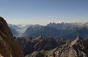
Monte San Lucano
| Monte San Lucano | ||
|---|---|---|
|
The Cima Pape o Sanson (grassy peak in the middle), on the left just behind the Pale di San Lucano (the peak peaks on the left are the Cime d 'Ambrusogn , the broad peak in the middle of the Monte San Lucano), for further details see file: Dolomitai4.JPG . |
||
| height | 2409 m slm | |
| location | Belluno , Italy | |
| Mountains | Pale di San Lucano , Dolomites | |
| Dominance | 3.5 km → Cima Pape o Sanson | |
| Notch height | 411 m ↓ Forcella Gardes | |
| Coordinates | 46 ° 18 '40 " N , 11 ° 57' 36" E | |
|
|
||
At 2409 m slm, Monte San Lucano is the highest mountain in the Pale di San Lucano , a subgroup of the Pala group in the Dolomites . It is located in the municipality of Taibon Agordino in the Italian province of Belluno and, together with the entire Pale di San Lucano, is part of the Dolomites World Heritage Site .
Location and surroundings
Monte San Lucano is located in the north ridge of the Pale di San Lucano, which connects it with the Quarta Pala di San Lucano in the west and the El-Mul peaks in the east, where the ridge runs out to Forcella Besausega . To the south, the mountain falls in a nearly 100 m high rock face to a connecting ridge , which leads to the southwest to the Spiz di Lagunàz and the Terza Pala di San Lucano and to the southeast to the rocky plateau of the Seconda Pala di San Lucano compared to the Prima Pala di San Lucano leads. In the north there is no large rock face, but the north slope is covered by scree fields and sometimes steep meadows, which can also contain smaller rock faces.
Alpinism
The ascent of Monte San Lucano usually takes place from Pradimezzo , a hamlet in the municipality of Cencenighe Agordino . From here you follow path no. 764 through the Valle del Torcòl to the Malga del Torcòl and to the Malga d 'Ambrusogn . Now you go on path no.765, first through the coniferous forest , then you climb over scree and mountain pines to Forcella Besausega , where an unmarked path leads below the north ridge of the Pale di San Lucano to Monte San Lucano. Here you can either climb the south face of the mountain or climb across meadows first to the ridge and finally to the summit.
You can also climb from Taibon Agordino on path no.765 first on the grassy plateau of the Prima Pala, where the Bivacco Bedin bivouac box is also available as an overnight stay, and then hike over scree and rock ledges to Forcella Besausega , where the path starts continue on the other ascent route.
map
- Compass maps , Trentino, sheet 683, map 2, 1: 50000

