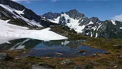
Mount Formidable
| Mount Formidable | ||
|---|---|---|
|
As a large jagged peak, Mount Formidable rises above the snow-covered mountain range |
||
| height | 2537 m | |
| location | Skagit County , Washington , USA | |
| Mountains | Northern Cascade Range | |
| Notch height | 575 m | |
| Coordinates | 48 ° 24 '59 " N , 121 ° 4' 2" W | |
| Topo map | Cascade Pass | |
|
|
||
| Type | folding | |
| Age of the rock | Triad | |
| First ascent | July 1938 by Calder T. Bressler, Ralph W. Clough, Bill Cox and Tom Myers | |
| Normal way | YDS class III | |
The Mount Formidable is a mountain in the North Cascades in Skagit County in the State of Washington . The first ascent was by members of the original Ptarmigan Traverse ; the summit is still a popular destination for rope teams on the Traverse. It was named by the pioneer mountaineer Herman Ulrichs in 1935 because of the rugged appearance of its northern flank. The summit is typically reached from Cascade Pass via the Ptarmigan Traverse.
Geography and climate
Mount Formidable lies on a side chain of the Cascades, about half a mile (800 m) west of the main ridge between Cascade Pass and Dome Peak , the overdrive tower of which is considered the actual massif, and about a mile (1.6 km) west of Spider Mountain. It is located in the climatic zone of the Marine West Coast , which causes heavy snowfalls to fall on it. The area is part of the temperate rainforest ecoregion on the Pacific coast ; therefore, lower areas are covered with very dense vegetation. The Middle Cascade Glacier , which drains over the Cascade River into the Skagit River , lies on the north side of the mountain.
geology
The North Cascades are made up of terrans or scattered, disjointed rock formations of various ages. More specifically, the immediate vicinity of Mount Formidable (i.e., within 10 mi (16 km)) consists mainly of granite rocks dating from the Mesozoic Era and slates from the Late Paleozoic Era . Mount Formidable itself probably consists of originally volcanic rocks that were formed in the Triassic and underwent metamorphosis in the late Cretaceous period .
Ascent
Access to Mount Formidable is usually via the Ptarmigan Traverse, which starts at Cascade Pass. Mountaineers ascend from Cascade Pass to Cache Col over the Cache-Col Glacier , then pass Kool-Aid Lake, a small, alpine lake that drains into the Middle Fork Cascade River. After that, they usually turn south towards the Middle Cascade Glacier over the Red Ledges, then around the south side of the mountain to the summit. However, there are alternative routes as well, most of which involve the climb from the Middle Cascade Glacier.
Web links
- Mount Formidable, Washington . peakbagger.com. 2013. Retrieved August 26, 2013.
- Mount Formidable at Peakware.com
- Mount Formidable at Summitpost.org
Individual evidence
- ↑ a b CASCADE PASS, WASH - NO 80 . Green trails. 1989. Archived from the original on May 19, 2012. Retrieved January 25, 2019.
- ↑ a b c d e f Fred Beckey: Mount Formidable . In: Kris Fulsaas, Christine Clifton-Thornton (eds.): Cascade Alpine Guide: Climbing and High Routes: Stevens Pass to Rainy Pass . 3. Edition. The Mountaineers Books, Seattle 2003, ISBN 0-89886-838-6 , pp. 265 ff . ( books.google.com - restricted reading sample).
- ^ Cascade River ( English ) In: Geographic Names Information System . United States Geological Survey .
- ^ Raymond Lasmanis: The geology of Washington: Rocks and Minerals. 1991. Cited in Geology of Washington - Northern Cascades . Washington State Department of Natural Resources. 2013. Archived from the original on October 8, 2014. Info: The archive link was automatically inserted and not yet checked. Please check the original and archive link according to the instructions and then remove this notice. Retrieved August 28, 2013 ..
- ↑ Fred W. Cater: Intrusive rocks of the Holden and Lucerne quadrangles, Washington - the relation of depth zones, composition, textures, and emplacement of plutons . In: United States Geological Survey (Ed.): Geological Survey Professional Paper . US Government Printing Office, 1982, pp. 1 ( books.google.com ).
- ↑ Fred W. Cater: Intrusive Rocks of the Holden and Lucerne Quadrangles, Washington. (PDF) 1982, pp. 9–23 , accessed on August 28, 2013 . .
- ^ Peggy Goldman: Washington's Highest Mountains. Basic Alpine and Glacier Routes . Wilderness Press, Birmingham, Alabama 2004, ISBN 0-89997-608-5 , pp. 84-87 ( books.google.com ).


