MountainsMap
| MountainsMap
|
|
|---|---|

|
|
| Basic data
|
|
| developer | Digital surf |
| Publishing year | 1996 |
| Current version | 7.0 |
| operating system | Microsoft Windows |
| category | Topography software |
| License | proprietary software |
| German speaking | Yes |
| www.digitalsurf.com | |
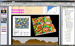
MountainsMap is a software for the display and measurement analysis of surfaces, which is developed and distributed by the company Digital Surf . The main area of application is microtopography - the analysis of surface properties and shape in 3D in the microscopic range. The software is mainly used in connection with tactile or optical profilometers , optical microscopes and scanning probe microscopes . Since version 7.0 there is also a MountainsMap version especially for scanning electron microscopes , with 3D reconstruction, and a version especially for hyperspectral microscopes and cameras (analysis of hyperspectral data cubes using techniques such as Raman , FTIR , EELS , EDX ).
MountainsMap is sold primarily as OEM software as an integrated or optional part of most profilometer and microscope manufacturers , mostly under their brand names; the software is sold for example as:
- TalyMap , TalyProfile , or TalyMap Contour on Taylor-Hobson's profilometers ,
- PicoImage on Agilent's atomic force microscope ,
- HommelMap on Jenoptik's profilometers (Hommel-Etamic product range),
- MountainsMap - X on Nikon's microscopes ,
- Apex 2D or Apex 3D on KLA-Tencors profilometers ,
- Leica Map to Leica microscopes ,
- ConfoMap on Carl Zeiss microscopes ,
- MCubeMap on Mitutoyo's profilometers ,
- MountainsMap Optical on Heliotis profilometers M3 and M3-XL 3D.
- SolarMap on optical profilometers and microscopes from Solarius GmbH.
MountainsMap is available in English , Brazilian Portuguese , Chinese , French , German , Italian , Japanese , Korean , Polish, and Spanish .
Individual evidence
- ↑ Surface display and metrology software on weltderproduktion.de
- ↑ Software for SEM and Multi-Spectral (Raman) Instruments in Imaging & Microscopy (Engl.)
- ↑ Digital Surf technology on Olympus Microscopes in Imaging and Microscopy (engl.)
- ↑ Surface analysis data to be sold with instruments in Engineering talk ( Memento of the original from July 26, 2008 in the Internet Archive ) Info: The archive link was inserted automatically and has not yet been checked. Please check the original and archive link according to the instructions and then remove this notice. (engl.)
- ↑ New Leica Map Surface Imaging and Metrology Software for Microscopy on nanowerk.com (Engl.)
- ↑ Carl Zeiss to Provide Surface Imaging Software from Digital Surf with Selected Microscopes on Azonano.com ( Memento of the original from October 7, 2012 in the Internet Archive ) Info: The archive link was inserted automatically and has not yet been checked. Please check the original and archive link according to the instructions and then remove this notice. (engl.)
- ↑ Mitutoyo Corporation signs OEM contract with Digital Surf (Engl.)
- ↑ Heliotis Optical Profilometers M3 and M3-XL 3D integrate MountainsMap® Imaging Topography Software on mikro-news.de
- ↑ Solarius-Europe, Products & Services. October 13, 2018, accessed on May 21, 2019 (German).
