Msta (river)
|
Msta Мста |
||
|
Rapids of the Msta river |
||
| Data | ||
| Water code | RU : 01040200212102000019715 | |
| location | Tver , Novgorod Oblast ( Russia ) | |
| River system | Neva | |
| Drain over | Volkhov → Neva → Baltic Sea | |
| origin |
Lake Mstino 57 ° 43 ′ 26 ″ N , 34 ° 28 ′ 16 ″ E |
|
| Source height | approx. 150 m | |
| muzzle | near Veliky Novgorod in the Ilmen Lake Coordinates: 58 ° 24 ′ 48 " N , 31 ° 20 ′ 15" E 58 ° 24 ′ 48 " N , 31 ° 20 ′ 15" E |
|
| Mouth height | 18 m | |
| Height difference | approx. 132 m | |
| Bottom slope | approx. 0.3 ‰ | |
| length | 445 km | |
| Catchment area | 23,300 km² | |
| Outflow location: 84 km above the mouth |
MQ |
202 m³ / s |
| Left tributaries | Beresaika , Schegrinka , Peretna , Lnjanaja , Cholowa | |
| Right tributaries | Uwer , Belaja , Mda , Chuba | |
| Medium-sized cities | Borovichi | |
|
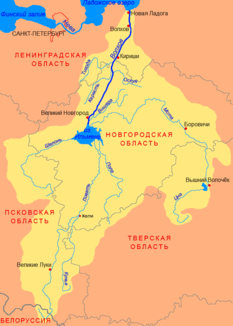
Course of the Msta (Мста) in the catchment area of the Volkhov |
||
The Msta ( Russian Мста ) is a 445 kilometer long Russian river that runs through the two oblasts of Tver and Novgorod . The largest city on the waterfront is Borowitschi .
course
The river has its origin in the Tver Oblast in the Valdai Hills in Mstino Lake (Мстино). It flows through the Novgorod Oblast and flows into the Ilmen Lake there . The Sievers Canal branches off shortly before the mouth and connects the Msta directly with the outflow of the Ilmen lake, the Wolchow . Although there are over 30 rapids in the river, it is navigable with the help of several locks and canals. There is also a connection to the Volga via the Vyshny Volotschok canal system .
The catchment area of the Msta covers 23,300 km². The discharge rate is 84 km above the mouth 202 m³ / s. The source height is about 150 m above sea level .

