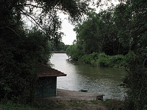
Mušlovský dolní rybník
| Mušlovský dolní rybník | ||
|---|---|---|

|
||
| View from the north of the pond | ||
| Geographical location | Czech Republic | |
| Tributaries | Mušlovský potok | |
| Drain | Mušlovský potok → Niklasgraben | |
| Location close to the shore | Sedlec | |
| Data | ||
| Coordinates | 48 ° 47 '44 " N , 16 ° 41' 2" E | |
|
|
||
| Altitude above sea level | 203 m nm | |
| surface | 5.9 ha | |
| length | 425 m | |
| width | 215 m | |
| volume | 64,000 m³ | |
| Maximum depth | 3.95 m | |
| Middle deep | 1.08 m | |
| Catchment area | 15 km² | |
The Mušlovský dolní rybník (German Kutlerteich , also Kutterteich ) is a fish pond in the district of Mikulov ( Nikolsburg ) in the Czech Republic . It is located two kilometers northwest of Sedlec ( Voitelsbrunn ) in the Pálava Protected Landscape Area .
geography
The pond is located north of the Mušlov settlement in the valley of the Mušlovský creek in the Milovická pahorkatina ( Milowice Hill ). Immediately above is the Mušlovský horní rybník ( Strelitz Pond ). The Mušlovský dolní rybník is surrounded by vineyards . To the north rises the Kienberg (258 m nm), in the northeast of the Vysoký roh ( Hocheck , 310 m nm), southeast of the Liščí vrch (298 m nm) and in the south of the Mušlov ( Muschelberg , 240 m nm).
South of the pond extends from the road Mikulov according Lednice ( Eisgrub ); above the dam, the trail of Mikulov Valtice ( field Berg ).
description
The pond dammed on its south side with an earth embankment dam has an area of 5.9 ha and a volume of 64,000 m³. At the outlet its water depth is 3.95 m and at the foot of the dam 3.20 m; the average depth of the pond is 1.08 m.
In the pond there is a species-rich vegetation of aquatic macrophytes .
history
The pond was probably created under the lords of Liechtenstein as a fishing pond for the Nikolsburg rule. In the Nikolsburger Urbar created in 1574 by the new landlord Adam von Dietrichstein , the Kutler pond was filled with 30 shock carp.
Below the Kutler pond there was another pond at Mušlovský potok, the pike pond , until the 19th century .
Web links
- Jana Laciná: Rybniční soustava CHKO Pálava - její characteristics a monitoring vybraných ukazatelů kvality vody , thesis, Palacký University Olomouc
- CHKO Pálava, Vodstvo
