
Mulde reservoir
| Mulde reservoir | |||||||
|---|---|---|---|---|---|---|---|
 |
|||||||
|
|||||||
|
|||||||
| Coordinates | 51 ° 38 '37 " N , 12 ° 24' 31" E | ||||||
| Data on the structure | |||||||
| Construction time: | 1972-1975 | ||||||
| Height above foundation level : | 19 m | ||||||
| Building volume: | 40,000 m³ | ||||||
| Crown length: | 303 m | ||||||
| Data on the reservoir | |||||||
| Altitude (at congestion destination ) | 79 m | ||||||
| Water surface | 630 ha | ||||||
| Reservoir length | 9 km | ||||||
| Reservoir width | 2 km | ||||||
| Storage space | 120 million m³ | ||||||
| Total storage space : | 135.5 million m³ | ||||||
| Design flood : | 2400 m³ / s | ||||||

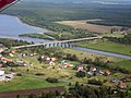
The Muldestausee is a flooded open pit in Anhalt-Bitterfeld / Saxony-Anhalt . Its neighboring locations are Friedersdorf , Schlaitz , Pouch and Mühlbeck . With a surface area of 6.3 km², it is the fourth largest body of water in the state of Saxony-Anhalt. Its length is about 9 km, its widest point 2 km, the greatest depth 35 m.
History of origin
After the Muldenstein open-cast mine was charred (1954–1975), it was necessary to relocate the hollow over a distance of about eleven kilometers in order to expand the Goitzsche open-cast mine (today's Großer Goitzschesee ) . Part of the new course of the river was laid through the charred open pit Muldenstein. The flooding took place in the period from April 30, 1975 to March 1, 1976. The Muldestausee has an inlet and an outlet structure.
Hydrology
The normal water level is around 79 m above sea level. NN with approx. 110 million m³ storage volume. The role of the Mulde reservoir as a flood retention basin is insignificant. However, the basin can temporarily hold back 15 million m³ during flooding (difference between total storage space and storage space). As a result, it is not actually a reservoir , but a river damming . Since the flow rate of the trough slows down considerably when it flows into the trough, the trough reservoir is a sedimentation trap into which approx. 400,000 t of solids (gravel, sand, silt) are introduced every year. These solids are missing from the river when it leaves the outlet structure, which leads to a deeper deepening of the river bed of the lower basin and has ecological effects.
Dam wall
The barrier structure near Friedersdorf is a 19 m high and 303 m long gravity dam with a structure volume of 40,000 m³.
Freetime activities
Many types of water sports are possible including sailing , surfing , camping , hiking, fishing, etc. The lake has very good water quality and an abundance of fish. There is a nature trail between Pouch and Friedersdorf .
Until the end of 2009 there was a passenger ship ("Muldeperle") on the lake that made tours.
gallery
Intake structure distant

Intake structure close

Dam wall

Outlet structure


See also
Web links
- The Muldestausee on braunkohlenstrasse.de
- Bitterfeld Online
- Leisure information from the Blue Ribbon
Individual evidence
- ↑ SILKE UNFROZEN: Bitterfeld: "Muldeperle" still dry. February 11, 2011, accessed on February 28, 2019 (German).
- ↑ MDR: Salvage Muldeperle difficult, ( page no longer available , search in web archives ) Info: The link was automatically marked as defective. Please check the link according to the instructions and then remove this notice. MDR, December 6, 2009. Retrieved July 13, 2010.
- ^ Naumburger Tageblatt: Passenger shipping Muldestausee discontinued, Naumburger Tageblatt, March 29, 2010. Accessed on July 13, 2010.