
Múli
.jpg)
Múli [ ˈmʉulɪ ] ( Danish : Mule ) is a formerly inhabited place in the Faroe Islands on the island of Borðoy , the largest of the six northern islands .
geography

The place is located in the extreme north on the east coast of Borðoy, at the foot of two peaks, the 642 meter high Knúkur and the 535 meter high Tindur. The gorge between these two peaks is called Múlagjógv .
Múli belongs to the Faroese municipality Hvannasund ( Hvannasunds kommuna ) and has the postcode FO-737. At the beginning of 2007 there were still three people living in the village, but the number of residents decreased steadily in the following years. The place has been officially uninhabited since 2015, but is still used as a summer and leisure residence.
history
The area around Múli must have been populated very early. The rgisdalur valley south of Múli, for example, suggests this. The word component Ærgis- is a linguistic memorial for a typical form of summer grazing which was abandoned in the 12th century and which spread to Ireland and Scotland over the Middle Ages.

The settlement of Múli itself can be dated back to the 13th century. The place is probably named after the mountainous end of land Múlin , at whose foot the village is located. The actual meaning of the word múli for the mouth or snout of an animal is often transferred figuratively to the Faroe Islands for a mountainous end of land .
The place is mentioned for the first time in written documents around 1350 to 1400 in the so-called dog letter . Múli is also listed in the royal inventory of goods from 1584, the so-called Jarðarbókin .
The most famous historical figure of the place is probably Guttormur í Múla , a son of Rasmus Magnussen and grandson of Magnus Heinason . Guttormur was originally from Haraldssund and lived from 1657 to 1737.
School lessons were only given in Múli from 1835, even if plans in this direction had been made 100 years earlier. Múli was the last place in the archipelago to receive electricity until 1970 . It was later connected to Norðdepil by road 743 to stop the threatened depopulation . However, Múli was already abandoned in 2002, although 3 residents were registered here in 2008. In summer, however, some former residents use their old houses as holiday apartments.
In the open-air museum of the Danish National Museum north of Copenhagen there are two old houses from Múli that were moved there and rebuilt.
Since 2006 all houses in the Faroe Islands have been given unique addresses with street names and house numbers. In 2007 the four houses in Múli also received addresses ( Múlavegur 1, 2, 3 and 4).
photos

The house “Har Frammi” in Múli in 1961 shortly before the demolition. The house was demolished brick by brick and board by board and later rebuilt in an open-air museum in Denmark.
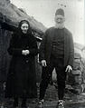
The residents in front of the "Har Frammi" house in Múli around 1940.
The house "Har Frammi" at its current location north of Copenhagen.
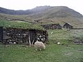
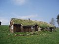
Stables in Múli that were still in use in 2008.

A Faroese when catching a Eissturmvogels ( havhestur ) with the so-called "fleygastong" north of Múli in the 1961st


.jpg)
Others

In the rocky surroundings of Múli there are still places of retreat for the Arctic Willow ( Salix arctica ), which has otherwise become rare in the Faroe Islands . The plant does not tolerate browsing by sheep well.
Web links
- Faroeislands.dk: Múli (in English, info page with photos)
- Guttormur í Múla , heimskringla.no
- Guttormur í Múla , Dimmalætting , March 7, 1992 (biography in Faroese)
Individual evidence
- ↑ Fólkatalsbroytingar skiftar á fødd, deyð, flutt og bygd, mánaðarliga (1985-2016) , hagstova.fo
- ↑ Fjøll í Føroyum , Umhvørvisstovan, us.fo (in Faroese)
- ↑ Hvussu gomul er bygdin , heimabeiti.fo (in Faroese)
- ↑ On page 10 under the Danish name Mulle : Jarðarbókin
- ↑ The Jarðarbókin 1584 is the oldest surviving register of royal estates on the Faroe Islands ( Jarðarbókin 1584 )
- ↑ Guttormur í Múla , heimskringla.no (in Faroese)
- ↑ “Fýra húsanummur í Múla” . portal.fo. February 23, 2007. Archived from the original on October 10, 2007.
Coordinates: 62 ° 21 ′ N , 6 ° 35 ′ W