Municipio Oruro
| Municipio Oruro | ||
|---|---|---|
 View of Oruro and the Cordillera Central |
||
| Basic data
|
||
| Population (state) - population density |
264,683 inhabitants (2012 census) 162 inhabitants / km² |
|
| Post Code | 04-0101 | |
| Telephone code | (+591) | |
| surface | 1,633 km² | |
| height | 3720 m | |
| Coordinates | 17 ° 58 ′ S , 67 ° 7 ′ W | |
|
|
||
| politics
|
||
| Department | Oruro | |
| province | Province of Cercado | |
| Central place | Oruro | |
| climate | ||
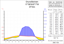
 Oruro climate diagram |
||
The Municipio Oruro is a district in the Oruro department in the highlands of the South American Andean state Bolivia .
Location in the vicinity
The Municipio Oruro is one of three Municipios in the Province of Cercado . It borders the Municipio Caracollo in the northwest , the Municipio El Choro in the southwest , the Province of Pantaleón Dalence in the southeast , and the Department of Cochabamba in the east .
The central and only place of the municipality is the city of Oruro with 264,683 inhabitants ( 2012 census ).
geography
The Municipio Oruro is located on the eastern edge of the Bolivian Altiplano in front of the high mountain range of the Cordillera Central . The vegetation of the region is sparse, because at this altitude no more lush growth is possible. In addition to vicuñas , alpacas and llamas, there are also the quirquincho , a small armadillo . Therefore, the inhabitants of Oruros are popularly called the Quirquinchos . The region has a typical time-of-day climate in which the daily temperature fluctuations are more pronounced than the temperature fluctuations between winter and summer.
The long-term average annual temperature is just under 11 ° C, the monthly values fluctuate between 6 ° C in June / July and 14 ° C in November (see climate diagram). Nocturnal frost temperatures are possible in almost every season. The annual precipitation is low 400 mm, whereby from April to November there is a pronounced dry season and only from December to March there is significant precipitation of up to 85 mm in the monthly average. Due to the low rainfall, the sky is mostly clear and an intense blue color.
population
The population of the Municipio Oruro has increased by about a third in the past two decades:
- 1992 : 196,025 inhabitants ( census )
- 2001 : 215,660 inhabitants (census)
- 2010 : 264,683 inhabitants (census)
The population density of the municipality at the last census in 2012 was 162 inhabitants / km², the life expectancy of newborns in 2001 was 63.7 years.
The literacy rate among those over 19 is 93 percent, 98 percent for men and 88 percent for women ( 2001 ).
politics
Results of the elections for the municipal council ( concejales del municipio ) in the regional elections on April 4, 2010:
| electoral legitimate |
electoral participation |
valid votes | MAS-IPSP | MSM | MCSFA | U.N. | UCS | PDC | MNR | ||
|---|---|---|---|---|---|---|---|---|---|---|---|
| 155.155 | 135.909 | 102,564 | 39,136 | 33,276 | 12,149 | 6,994 | 4,516 | 3,979 | 2,514 | ||
| 87.6% | 75.5% | 38.2% | 32.4% | 11.8% | 6.8% | 4.4% | 3.9% | 2.5% |
structure
The municipality is not further divided into cantons and consists exclusively of the city of Oruro .
Individual evidence
- ^ Instituto Nacional de Estadística Bolivia (INE) 1992
- ^ Instituto Nacional de Estadística (INE) 2001
- ↑ Instituto Nacional de Estadística (INE) 2012 ( Memento of the original of July 22, 2011 in the Internet Archive ) Info: The archive link has been inserted automatically and has not yet been checked. Please check the original and archive link according to the instructions and then remove this notice.
- ↑ Acta de computo Nacional Electoral Departamentales, Municipales y Regional 2010
Web links
- Municipio Oruro - General Maps No. 40101
- Municipio Oruro - detailed map and population data (PDF; 535 kB) ( Spanish )
- Departamento Oruro - Social data of the municipalities (PDF 5.86 MB) ( Spanish )
