Muránska planina


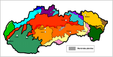
The Muránska planina ( German Muraner plateau ) is a 25 km long and 10 km wide plateau in central Slovakia .
Location and limitation
The plateau lies in the Banskobystrický kraj . Geomorphologically it is part of the Spišsko-gemerský kras ( Spiš-Gemer-Karst ), which in turn belongs to the Slovak Ore Mountains .
The plateau is limited
- in the north of the valley of the river Hron ( Horehronie region ),
- in the northeast of Slovenský raj ( Slovak Paradise ),
- in the east and south of the Stolické vrchy mountains ,
- in the west of the Veporské vrchy mountains .
character
The plateau is a region characterized by karst phenomena . Geologically, it consists of limestone and dolomite .
On the Muránska planina, endemic plants can be found in addition to mixed deciduous forests and pasture areas, e.g. B. the Slovak daphne ( Daphne arbuscula ) or the Slovak endemic Carpathian schöterich ( Erysimum wittmanni ).
The highest point is the Kľak with 1409 m.
Attractions
In addition to the landscape, Muráň Castle is a special tourist attraction.
natural reserve
In 1997 the Muránska Planina National Park was established on an area of 203 km² with a surrounding protection zone of 217 km². A number of special natural structures were placed under special protection.
Some places in the mountains and in the vicinity
- Brezno
- Červená Skala (part of Šumiac )
- Muráň
- Tisovec
Remarks
- ↑ The highest mountain in the Muránska Planina National Park is Fabová hoľa (1439 m), which geomorphologically, however, is already counted among the Veporské vrchy.
Web links
Coordinates: 48 ° 46 ' N , 20 ° 0' E