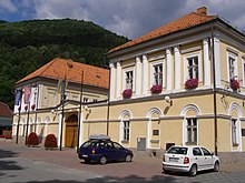
Tisovec
| Tisovec | ||
|---|---|---|
| coat of arms | map | |

|
|
|
| Basic data | ||
| State : | Slovakia | |
| Kraj : | Banskobystrický kraj | |
| Okres : | Rimavská Sobota | |
| Region : | Gemer | |
| Area : | 123.426 km² | |
| Residents : | 4,087 (Dec 31, 2019) | |
| Population density : | 33 inhabitants per km² | |
| Height : | 411 m nm | |
| Postal code : | 980 61 | |
| Telephone code : | 0 47 | |
| Geographic location : | 48 ° 41 ′ N , 19 ° 57 ′ E | |
| License plate : | RS | |
| Kód obce : | 515680 | |
| structure | ||
| Community type : | city | |
| Urban area structure: | 2 districts | |
| Administration (as of November 2018) | ||
| Mayor : | Irena Milecová | |
| Address: | Mestský úrad Tisovec Námestie Dr. V. Clementisa 1 98061 Tisovec |
|
| Website: | www.tisovec.com | |
| Statistics information on statistics.sk | ||
Tisovec (German Theissholz , Hungarian Tiszolc , Latin Taxovia ) is a town in the Neusohl Regional Association in southern Slovakia . It is located in the western and eastern parts of the Slovak Ore Mountains on the Rimava River . The name comes from the Slovak word tis (German yew ).
history
It was mentioned in writing for the first time in 1334 as Thyzolch / Tyzolch and consists of the parts Rimavská Píla (incorporated on January 1, 1979) and Tisovec. The place was founded by German colonists in the 12th century, the German population assimilated over the centuries. In 1596 the place was granted market rights, and in 1780 also city rights.
Until 1918 the municipality in Gemer and Kleinhont County belonged to the Kingdom of Hungary and then came to the newly formed Czechoslovakia .
According to the 2001 census, of 4,215 inhabitants, 95.75% were Slovaks, 2.87% Roma, 0.78% Czech and 0.43% Hungarians. The most represented denomination was the Protestant with 32.91%; 29.54% declared themselves to be Roman Catholic and 0.43% believed to be Greek Catholic. 34.59% were non-denominational.
Town twinning
-
 Putnok , Hungary
 -
 Ludgeřovice , Czech Republic
 -
 Nowy Żmigród , Poland
 -
 Shenandoah , United States
Personalities
- Štefan Marko Daxner (1822–1892), Slovak politician and author in the 19th century
- Vladimír Clementis (1902–1952), Slovak communist politician and writer

