Myrtleford
| Myrtleford | |||||||
|---|---|---|---|---|---|---|---|
 Myrtleford |
|||||||
|
|||||||
|
|||||||
|
|||||||
|
|||||||
|
|
|||||||
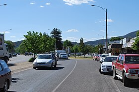
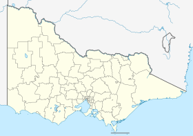
Myrtleford is a city in the northeast of the Australian state of Victoria , 45 km southeast of Wangaratta and 275 km northeast of Melbourne . The city belongs to the Local Government Area Alpine Shire and had a population of 2,782 according to the 2016 census.
history
The Aborigines inhabited the alpine valleys and plateaus for thousands of years before the first immigrants from Europe came. They knew the flora and fauna, the geography and the seasonal changes. Groups of indigenous people visited the Australian Alps in the summer and gathered the nutritious Bogong moths that had retreated there. Settlement by Europeans began in the early 19th century, and from 1837 there was a remote cattle breeding station called Myrtle Creek Run . The settlers who fence in the cattle breeding station gave it this name.
When gold was found in Buckland Valley , thousands of gold diggers had to cross Myrtle Creek on their way to the gold fields. A small settlement developed at the ford, which was named Myrtleford . The road through Myrtleford was called Buckland Road ; today it is called the Great Alpine Road . The settlement received its own post office on July 26, 1858. It was initially called Myrtle Creek and was later renamed Myrtleford.
Myrtleford today
Myrtleford is the largest city in the LGA Alpine Shire and a major trading center for the Ovens River and Buffalo River valleys . Carter Holt Harvey makes wood products in Myrtleford. Tobacco growing was an important industry for many years, but in 2006 the tobacco industry withdrew from the city. Agriculture is also important; there are wine , walnuts , chestnuts , blueberries , raspberries , cherries , apples , kiwis , olives , vegetables and hops grown. Cattle and dairy farming are the predominant branches in the region. The area has an Australian continental climate, which corresponds to the Mediterranean climate . In midsummer, the maximum temperatures are 31.9 ° C, the minimum temperatures 14.1 ° C. In winter, the maximum temperatures reach 12.9 ° C and the minimum temperatures 2.4 ° C. The mean amount of rain is 66.9 mm.
Myrtleford has a football team that plays in the Ovens & Murray Football League .
sons and daughters of the town
- Malcolm Milne (born 1948), ski racer
- Ross Milne (1944–1964), ski racer
- Kerryn Pethybridge-Rim (born 1962), biathlete
Web links
Individual evidence
- ↑ a b Australian Bureau of Statistics : Myrtleford ( English ) In: 2016 Census QuickStats . June 27, 2017. Retrieved April 19, 2020.
- ^ Post Office List . Premier Postal History
- ↑ Myrtleford. Full Points Footy ( Memento of the original dated April 6, 2008 in the Internet Archive ) Info: The archive link was inserted automatically and has not yet been checked. Please check the original and archive link according to the instructions and then remove this notice.

