Mývatn
| Mývatn | ||
|---|---|---|

|
||
| Mývatn | ||
| Geographical location | Iceland | |
| Drain | Laxá í Aðaldal | |
| Islands | total approx. 40 | |
| Places on the shore | Skútustaðir, Reykjahlíð | |
| Data | ||
| Coordinates | 65 ° 36 '0 " N , 17 ° 0' 36" W | |
|
|
||
| Altitude above sea level | 288 m | |
| surface | 37 km² | |
| Maximum depth | 4.2 m | |
| Middle deep | 2.3 m | |

|
||
| Pseudocrater in Mývatn | ||
The Lake Myvatn [ 'miːvahtn̥ ] ( Icelandic "my", "mosquitoes", "vatn", "water" - German "midges" ) located on the territory of the municipality Skútustaðir in the northeast of Iceland in the area of Krafla - volcanic system .
Surname
The lake takes its name from the sometimes very large swarms of mosquitoes in summer , which are the basis for the considerable abundance of fish and the diverse duck population . Most of them are harmless mosquitoes that do not bite, but black flies that sting also occur. In summer there are two periods of around two weeks each when the mosquitoes form real black columns on the shore of the lake. That is why this species of mosquito is also called Rykmý , the dust mosquito in Icelandic .
The steadily through the volcanic activity escaping from the ground and the lake dioxide acts schwarminduzierend, which may result as well as the carbon dioxide exhaled by mammals that mosquitoes invade directly oral and nasal cavities. There are historical records of some cases where horses choked to death due to the airway being blocked with mosquitoes. The surrounding Mývatn region is named after the lake .
location
The lake is located about 50 kilometers south of the coastal town of Húsavík and has an area of 37 km². This makes it the fourth largest lake on the island. With a maximum depth of 4.2 m, it is relatively shallow, and on average it is only 2.3 m. At a lake level of about 288 m above sea level. M. the neighboring settlements form the highest year-round inhabited areas of Iceland, which gives an indication of the favorable climatic situation of the lake in summer. The outflow of the Mývatn is the Laxá í Aðaldal river .
As a tourist destination, it is particularly suitable because of the extremely varied lava formations and the very active volcanism . This is based on the approximately 40 km long volcanic system of the central volcano Krafla . The last outbreaks in the area occurred from 1975 to 1984.
The peaks of Vindbelgjarfjall in the north of the lake and steaming Námafjall in the north-east offer a beautiful view over the lake. There are hiking trails on both.
Volcanism on Mývatn
In the vicinity of the lake there are numerous natural wonders of volcanic origin, as it belongs to the catchment area of the Krafla volcanic system .
In the lake itself you can see the pseudocraters of Skútustaðir on islands and peninsulas , which, however, did not emit volcanic material themselves, but were created by the explosive collision of lava and water.
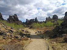
In addition, the volcanic explosion crater of Hverfjall (or Hverfell ) is not far from the lake, which can also be climbed. Below the Hverfjall lies the area of Dimmuborgir (German for "dark castles"), attractive tufa formations , but their existence is threatened. In the vicinity of the lake you can also find the crater series Lúdentsborgir , table mountains and shield volcanoes . The Grjótagjá and Stóragjá bathing caves can again be used to a limited extent for bathing due to the meanwhile slightly lower temperatures. In their vicinity you can see a visible crack that separates the Eurasian from the American plate. Columns of water rising up like a fountain have already been observed along the approximately 20 km long fissure.
The church of Reykjahlíð on the shore of the lake was spared from a lava flow in the 18th century and with it the inhabitants of the village at that time. The current church was built in 1962.
The ducks of Mývatn
The large number of different species of ducks make the lake a research subject for ornithologists . Wigeons and long-tailed ducks can be found here, for example . The collar duck , whose European breeding area is restricted to Iceland, is particularly common on the Mývatn. The reason for the numerous insects and the birds that feed on them is that the Mývatn is on the one hand very flat and on the other hand it is fed by hot springs underground. That is why it only partially freezes over in winter.
The diatomite
For a long time, in the northern part of Lake Mývatn near the town of Reykjahlíð, diatomaceous mud was extracted and processed into diatomite , which was controversial in terms of environmental policy. The plant was then closed and demolished, and the company was privatized. Over 100 people lost their jobs, which threatened the very existence of this area.
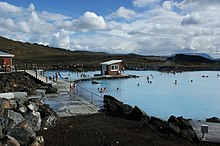
To compensate, parts of the proceeds from the privatization were used to expand the thermal baths " Jarðböð " (German for earth baths ) in order to create new jobs. The bath, which was reopened in 2004 (it was already in use between 1950 and 1970), is part of Icelandic bathing culture .
Others
The Mývatn Marathon has been taking place around the lake since 2002 .
Mývatn as namesake
The Icelandic lake is the namesake of a methane lake on Saturn's moon Titan, the Mývatn Lacus .
See also
Web links
- Search engine with map of Iceland (via Reykjahlið)
- Geological representation of the Mývatn area, geolog. Inst. Univ. Iceland (English)
- The Myvatn area
- National Park Service: Information about Myvatn area with description of hiking trails (English)


