
Napadivka
| Napadivka | |||
| Нападівка | |||

|
|
||
| Basic data | |||
|---|---|---|---|
| Oblast : | Ternopil Oblast | ||
| Rajon : | Lanivtsi district | ||
| Height : | no information | ||
| Area : | 3.633 km² | ||
| Residents : | 1,128 (2001) | ||
| Population density : | 310 inhabitants per km² | ||
| Postcodes : | 47415 | ||
| Area code : | +380 3549 | ||
| Geographic location : | 49 ° 53 ' N , 26 ° 2' E | ||
| KOATUU : | 6123880602 | ||
| Administrative structure : | 1 village | ||
| Address: | 47412 с. Борсуки | ||
| Website : | Municipal Council website | ||
| Statistical information | |||
|
|||


Napadivka ( Ukrainian Нападівка ; Russian Нападовка Napadowka , Polish Napadówka ) is a village in the northeast of the Ukrainian Ternopil Oblast with about 1100 inhabitants (2001).
The village, first mentioned in writing in 1470, is the most populous village in Laniwzi Rajon and administratively belongs to the rural community of the neighboring village of Borsuky in the east of the Rajon.
Napadivka is located on the right bank of the Horyn , a tributary of the Pripyat , and on the territorial road T-20-09 between the community center Barsuky in the west and the Rajonzentrum Laniwzi in the east. The Ternopil Oblast Center is located about 60 km southwest of Napadivka.
Wooden church in the village

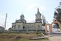
Orthodox Church in Napadivka

Town center with a war memorial


Web links
- Napadówka (1) . In: Filip Sulimierski, Władysław Walewski (eds.): Słownik geograficzny Królestwa Polskiego i innych krajów słowiańskich . tape 6 : Malczyce – Netreba . Walewskiego, Warsaw 1885, p. 898 (Polish, edu.pl ).
Individual evidence
- ↑ Local website on the official website of the Verkhovna Rada ; accessed on December 5, 2017 (Ukrainian)
- ↑ history Napadiwka in the history of the towns and villages of the Ukrainian SSR ; accessed on December 5, 2017 (Ukrainian)