Herbringhauser Bach
| Herbringhauser Bach | ||
|
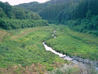
The former storage space of the lower Herbringhauser dam |
||
| Data | ||
| Water code | DE : 2736392 | |
| location | Wuppertal | |
| River system | Rhine | |
| Drain over | Wupper → Rhine → North Sea | |
| source | At Lennep 51 ° 12 ′ 3 ″ N , 7 ° 16 ′ 4 ″ E |
|
| Source height | 328 m above sea level NN | |
| muzzle | Northwest of Beyenburg in the Wupper Coordinates: 51 ° 15 ′ 12 " N , 7 ° 16 ′ 15" E 51 ° 15 ′ 12 " N , 7 ° 16 ′ 15" E |
|
| Mouth height | 183 m above sea level NN | |
| Height difference | 145 m | |
| Bottom slope | 20 ‰ | |
| length | 7.1 km | |
| Catchment area | 9.269 km² | |
|
The Herbringhauser Bach flows into the Wupper near the Wupper Bridge Theodor-Schröder-Weg |
||
|
Tributaries and hydraulic structures
|
|||||||||||||||||||||||||||||||||||||||||||||||||||||||||||||||||||||||||||||||||||||||||||||||||||||||||||||||||||||||||||
The Herbringhauser Bach is a 7.103 kilometer long brook and a tributary of the Wupper , which has its source in Remscheid near the city limits of Wuppertal . He covers the longest distance in the Wuppertal district of Langerfeld-Beyenburg .
etymology
The etymological origin of the old place name Herbringhausen comes from "Haribrahtinghuson", from which "Herbrechinchusen" was derived in 1397, which goes back to the personal name "Heribraht". The place was mentioned in 1457 as the property of the Duke von Berg .
In the late Middle Ages until the 18th century, the brook was named Olpebach or Olper Bach . The Hofschaft Olpe and the Olper Höhe on the upper reaches are associated with this name. The large forest area in the middle and lower reaches, which is called Herbringhauser Wald today, was called Olscheid at that time , also derived from Olpe .
topography
The stream rises at around 340 meters above sea level in the Lüttringhausen district near the Remscheid Ringstrasse (Landesstrasse 58, formerly Bundesstrasse 51 ) and flows north through the Garschager Heide . After about one kilometer from the source, the city limits of Wuppertal are reached and the 200-meter-long Grunewaldsiepen flows into the Herbringhauser Bach from the right . After another 180 meters, the 476 meter long Lusebuschsiefen also comes from the right . The 608 meter long Cluser Bach flows after another 260 meters from the right. About 1.6 kilometers from the source, the 1.6 kilometer long Garschagen Bach flows from the left .
After another 150 meters, the "Kreuzmühle" basin of the Herbringhauser dam is reached. This approx. 420 meter long pre-basin is interrupted by Landesstraße 81 . The Herbringhauser Bach is then dammed in the Herbringhauser Dam. The stream is named after the dam, which is around two kilometers long. Further tributaries on the right and left feed the dam. The Herbringhausen waterworks is located 200 meters below the dam .
A small pond is reached 4.4 kilometers from the source. The small district of Herbringhausen is located around 500 meters west of the stream . So far, the main direction of flow has been in a northerly direction, for around 900 meters it flows in a north-westerly direction, only to flow again in a northerly direction. About six kilometers from the source is the valley of the former Lower Herbringhauser dam , which was closed in 2006 . Herbringhauser Tal is now supposed to develop into a stream again . The forest area on the east bank of the stream is called Sondernbusch . Shortly behind the dam, the Herbringhauser Bach flows as the left tributary of the Wupper at around 200 meters above sea level in the small district of Kemna .
Water engines
At the Herbringhauser, like most of the streams in the Wupperviereck, the water was used to drive water wheels . The first water drive on the barrel was the Kreuzmühle , which was first mentioned in 1597 and burned down in 1955. In the course of the construction of the Kreuzmühle fore basin, all remains were removed. The Luckhausen mill was removed during the construction of the Herbringhauser dam, as well as the Herbringhauser hammer, first mentioned in 1550 . Further down the stream followed the Oberste Hammer , the Mittlere Hammer and the Unterste Hammer ( Grabers Hammer ) shortly before the mouth of the Wupper, some of which were also mentioned in 1550 and processed steel up to the construction of the dam. All of these structures no longer exist and only place names partially remind of them.
Landwehr
The Bergische Landwehr crossed the Herbringhauser Bach in two places . While the Barmer line crossed the valley at the level of the Untere Herbringhausen dam coming from the Paulsberg , the Elberfeld Landwehr ran across the stream at the level of Herbringhausen.
natural reserve
The valley of the Herbringhauser Bach is under nature protection on an area of 49 hectares .
literature
- Günther Schmidt; Hammer and Kotten research in Remscheid , Volume 5: from Blombach to Eschbach ; Publisher: Buchhandlung R. Schmitz; Remscheid; 2006; ISBN 3-9800077-6-6
See also
Individual evidence
- ↑ a b Measurement based on the German basemap 1: 5000
- ↑ a b Topographical Information Management, Cologne District Government, Department GEObasis NRW ( Notes )
- ↑ River Geographic Information System of Wupperverbandes
- ^ Wolfgang Stock: Wuppertal street names . Thales Verlag, Essen-Werden 2002, ISBN 3-88908-481-8
Web links
- "Herbringhauser Bach" nature reserve (W-006) in the specialist information system of the State Office for Nature, Environment and Consumer Protection in North Rhine-Westphalia

