Nedalshytta
| Nedalshytta | ||
|---|---|---|
|
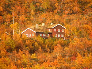
Nedalshytta in autumn 2008 |
||
| location | Plateau in the municipality of Tydal , west of the Sylan , Trøndelag Province , Norway ; Trøndelag , Norway | |
| Geographical location: | 62 ° 58 '41.7 " N , 12 ° 6' 4.3" E | |
| Altitude | 780 moh. | |
|
|
||
| owner | Norwegian Trekking Association (DNT) | |
| Construction type | Hut with restaurant | |
| Development | Road to the hut | |
| Usual opening times | Late March to late April and mid June to late September | |
| accommodation | 88 beds, 0 camps | |
The Nedalshytta is a hiking and shelter of the Norwegian Trekking Association (DNT). It is operated by the regional association Trondhjems Turistforening and has a total of 88 beds, of which 60 are rented out during the hours that are open and 28 when not in use, and can be accessed with a universal key from the DNT.
Location and surroundings
Nedalshytta is located in a small birch forest on a plateau in the municipality of Tydal , on the south- eastern shore of Lake Nesjøen , west of the Sylan Mountains.
history
The hut was built in 1971 and replaced the old Nedalshytta, which was abandoned when the Nesjøen lake was dammed and the former hut is now on the lake's bottom.
ways

Starting from the hut, a network of a total of 820 km of marked hiking trails is available, 370 km of which are on the Norwegian and 450 km on the Swedish side. The hut itself is connected to road 705 ( Stjørdal - Røros ) by a small road .
Tours from the Nedalshytta / summit climbs
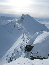
The main destination of the numerous hiking routes is the Sylan Mountains in the east of the Nedalshytta. The most important and best-known (circular) hiking trail is the Store Syltraversen.

Store Syltraversen
The Store Syltraversen is a circular hiking trail which, in addition to easily accessible hiking trails, also has sections that require surefootedness and a head for heights. On the stretch between Storsola and Lillsylen you can see for miles over Norway and Sweden in good weather.
Starting from the Nedalshytta, the Store Syltraversen leads over the Ekorrpasset pass and a narrow mountain ridge past the small Ekorn and Tempelbreen glaciers to the Storsola . From there it is around 5 km to Storsylen . From Storsylen the path leads over the Sylryggen- Bergsattel to Lillsylen and finally back to Nedalshytta.
Transitions to other huts
A total of 19 other huts can be reached from the hut via the extensive network of hiking trails. These include Græslihytta , Kjølihytta , Ramsjøhytta , Schulzhytta , Storerikvolle (all Norway) and, on Swedish territory, the Blåhammaren Fjällstation and the Sylarnas Fjällstation . The latter three are directly connected to the Nedalshytta via the Firkanten circular route.
Web links
Individual evidence
- ↑ a b c d Nedalshytta ( Memento of the original from April 14, 2013 in the Internet Archive ) Info: The archive link was inserted automatically and has not yet been checked. Please check the original and archive link according to the instructions and then remove this notice. , ut.no, accessed December 16, 2011 (Norwegian)
- ↑ a b c d Sylan: Visiting ( page no longer available , search in web archives ) Info: The link was automatically marked as defective. Please check the link according to the instructions and then remove this notice. , midtnorsknatur.no, accessed on December 16, 2011 (English)

