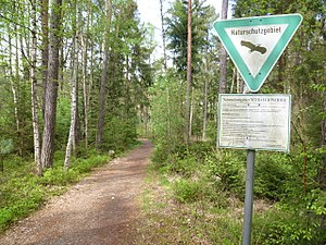
Neubäuer pond
|
NSG Neubäuer Weiher
|
||
|
Neubäuer pond |
||
| location | Neubäu , Cham district , Bavaria | |
| surface | 34.33 ha | |
| Identifier | NSG-00429.01 | |
| WDPA ID | 164784 | |
| Natura 2000 ID | [https://www.bfn.de/themen/natura-2000/natura-2000-gebiete/steckbriefe/natura/gebiete/show/ffh/DE6740301.html 6740-301 6740-301 ] | |
| Geographical location | 49 ° 15 ' N , 12 ° 26' E | |
|
|
||
| Setup date | 1992 | |
The Neubäuer Weiher is a nature reserve and FFH area near Neubäu am See in the Upper Palatinate district of Cham in Bavaria .
The nature reserve is located 1.2 kilometers northeast of Neubäu. It is located in the Upper Bavarian Forest Nature Park and is part of the LSG landscape protection area within the Upper Palatinate Forest Nature Park (formerly a protection zone) and the congruent fauna-flora-habitat area Neubäuer Weiher .
The 34 hectare area includes the northern shallow water zones, the shores of Lake Neubäuer and the adjacent forest area. The silting areas and the adjoining Scots pine felt are of particular vegetation quality . It is a regionally important resting and breeding area for endangered bird species.
The nature reserve was placed under protection on December 2, 1992.
See also
Individual evidence
- ↑ Location of the nature reserve in the Bavaria Atlas (accessed on March 5, 2017).
- ↑ LSG within the Upper Palatinate Forest Nature Park (formerly protection zone) at protectedplanet.net (accessed on March 4, 2017)
- ↑ 6740-301 Neubäuer Weiher. (FFH area) Profiles of the Natura 2000 areas. Published by the Federal Agency for Nature Conservation . Retrieved November 25, 2017.
- ↑ Neubäuer Weiher at protectedplanet.net (accessed on March 4, 2017)
- ↑ www.regierung.oberpfalz.bayern.de, Ordinance of the nature reserve (accessed on March 5, 2017)


