New Beresinchen
|
New Beresinchen
City of Frankfurt (Oder)
Coordinates: 52 ° 19 ′ 20 ″ N , 14 ° 32 ′ 11 ″ E
|
|
|---|---|
| Residents : | 5708 (Dec. 31, 2015) |
| Area code : | 0335 |
|
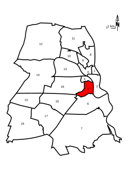
Regional division of Frankfurt (Oder) highlighted with Neuberesinchen
|
|
|
View over Neuberesinchen in 2006. Most of the prefabricated buildings have disappeared today
|
|
Neuberesinchen is a district of the independent city of Frankfurt (Oder) southeast of Berlin in Brandenburg .
Geographical location
Neuberesinchen is located south of downtown Frankfurt, right next to the Altberesinchen district, with which Neuberesinchen forms the large Beresinchen district. To the west is the southern district. The villages Güldendorf and Lossow , which belong to Frankfurt (Oder), arrive in the south . To the east lies the Guben suburb .
The city center and train station are within walking distance, the city center and the motorway can be reached via the street, and a tram line running through the entire residential area provides a connection to the city center.
history
The area of today's Neuberesinchen extends above all over the former area of the part of the city field with numerous vineyards to the southwest of the walled city. This manure land, located near the city, was tilled annually by the arable farming residents. The vineyards with wineries and wine presses belonged to Frankfurt patrician families .
During the Thirty Years' War many fields and mountains remained desolate and served as a deployment area for the troops besieging the city. From the siege by the Swedish troops in 1631 the name "Schwedenschanze" was given. More and more vineyards were converted into orchards and fields. After 1775 the picture of this area changed. While the mountains remained in the possession of the city and various citizens, the entire arable land was redistributed as a result of the "separation". If the property of the individual was previously split up in the various fields of the town and Hufenfeld, now everyone received his entire field in one place, could fence it in and cultivate it regardless of his neighbors. With the separation, the numerous paths leading across the farmland to the neighboring villages disappeared .
In the mid-1920s, the large areas were further subdivided and more and more single-family houses were built . New streets were built (Gustav-Adolf-Straße, Hans-Sachs-Straße). The Trowitzsch factory settlement was built between Heinrich-Hildebrand-Strasse (partly renamed Trowitzsch-Strasse / Gutenbergstrasse) and Schwedenschanze ("Freedom" after 1945). From 1977 to the 1990s, a good 8,000 apartments were built in Neuberesinchen, originally for 23,000 residents. The social policy approach was to eliminate the housing shortage in Frankfurt (Oder) and at the same time to create living space for the settlement of new workers for the expanding Frankfurt industry ( microelectronics ). The residential area was equipped with recreational and leisure facilities, while the workplaces, u. a. in the planned commercial area adjacent to the south, should be quickly accessible by tram and the existing road connection.
Population development
| year | 1989 | 2001 | 2006 | 2013 | 2014 | 2015 |
|---|---|---|---|---|---|---|
| population | 21,547 | 13,145 | 9080 | 6323 | 6019 | 5708 |
| source |
traffic
The four-lane B112 runs through Neuberesinchen and is called "Heinrich-Hildebrand-Str." From Leipziger Strasse and between the main cemetery and Neuberesinchen "Am Goltzhorn". Furthermore, the Birkenallee, the Mühlenweg and the Johann-Eichorn-Str. to be mentioned as important access roads. Neuberesinchen is well connected to the local public transport network of trams and buses. There are tram lines 1 to the stadium and on weekdays also the 5 to the exhibition grounds. From Monday to Friday during rush hour they form a 10-minute cycle between Neuberesinchen and the city center. The bus route 986 serves the Neuberesinchen stop in the summer months and connects the train station with the local recreation area at the Helenesee . The 987 bus runs from Monday to Saturday between Neuberesinchen and various shopping centers on Südring, Messering, in Josef-Gesing-Str. via Hansa-Nord to the Spitzkrug-Multi-Center. Furthermore, the inner-city night line N2 serves almost all stops in Neuberesinchen. The tram and bus depot of the Frankfurt (Oder) city transport company and a stop called Frankfurt (Oder) -Neuberesinchen on the single-track route to Grunow-Königs Wusterhausen ( regional train line 36 ) are also located in Böttnerstraße .
outlook
The city of Frankfurt (Oder) plans to demolish 2,245 apartments in Neuberesinchen by 2025, as the city's population has been declining for years.
Web links
Individual evidence
- ↑ a b c Cathrin Knop, Henry Maus: Residents with main residence: Basic demographic formula - City of Frankfurt (Oder) - Urban areas - Year 2015. (PDF; 122 kB) City of Frankfurt (Oder), population register, municipal statistics office, May 26, 2016, accessed on January 12, 2016 . (Neuberesinchen north and south added)
- ↑ Book cover “The practical advice in fruit and gardening” by Eugen Trowitzsch
- ↑ a b c City of Frankfurt (Oder)
- ↑ Cathrin Knop: Residents with main residence: Basic demographic formula urban areas 2014. (PDF; 123 kB) City of Frankfurt (Oder), residents' register, municipal statistics office, May 5, 2015, accessed on January 12, 2016 . (Neuberesinchen north and south added)
- ↑ Martin Stralau: By the end of 2017, 21 houses will fall. In: Märkische Online Zeitung. February 17, 2014, accessed July 12, 2016 .


