Neubrunn (Neubrunn, Lower Franconia)
|
Neubrunn
Neubrunn market
Coordinates: 49 ° 43 ′ 50 ″ N , 9 ° 40 ′ 14 ″ E
|
|
|---|---|
| Height : | 283 m above sea level NHN |
| Postal code : | 97277 |
| Area code : | 09307 |
|
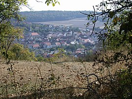
Distance view of the center of Neubrunn
|
|
Neubrunn is the main town in the Neubrunn market in the Lower Franconian district of Würzburg in Bavaria .
geography
location
The place is 283 m above sea level. NHN between Wertheim and Würzburg on the district road WÜ 59 crossed by the district road WÜ 11 . In addition, in the east of the village, the district road WÜ 17 merges into the district road WÜ 11 and in the west of the village the district road WÜ 60 joins the district road WÜ 59.
Neighboring marks
Neighboring markings starting clockwise in the north are Holzkirchhausen , Helmstadt , Unteraltertheim , Wenkheim , Böttigheim , Höhefeld and Kembach .
Waters
The Schomickelgraben flows into the Mühlbach, a source brook of the Kembach , which rises in the northern district and flows through the village .
history
Neubrunn was a municipality in the Marktheidenfeld district until its dissolution. Since July 1, 1972, Neubrunn has been part of the Würzburg district .
religion
Neubrunn is shaped by Catholicism. The parish of St. Georg belongs to the deanery of Würzburg on the left of the Main .
Architectural monuments
Numerous buildings are under monument protection . see: List of architectural monuments in Neubrunn
Web links
Individual evidence
- ↑ a b Right click on the BayernAtlas of the Bavarian State Government ( information ).
- ↑ All deaneries. Diocese of Würzburg, accessed on August 28, 2017 .


