Neufeld (Thun)
| Neufeld (Thun) | |
|---|---|
| State : |
|
| Canton : |
|
| Administrative district : | |
| Residential municipality : | Tuna |
| Coordinates : | 613 393 / 176 672 |
| Residents: | 8955 (2015-12-31) |
| Website: | neufeldleist.ch |
| map | |
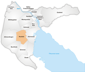
The Neufeld is a district of Thun in Switzerland .
geography
The Neufeld is located southwest of the old town of Thun, in the center of the area of the formerly independent municipality Strättligen . In the east it borders on Dürrenast , in the south on Gwatt- Schoren-Buchholz, in the west on Allmendingen (separated from agricultural land and the Autobahn 6 ), in the north-west on the Allmend used by the army and in the north-east on the Hohmad -Quartier.
The entire area of the quarter is on the plain between the northwestern tip of Lake Thun and the moraine hills to the west of it. However, it has no sea stumbling block.
history
The area of today's quarter was originally known as "Vehweid" (cattle pasture). This name was first mentioned in a document in 1577. Until the diversion of the Kander into Lake Thun in 1714, the area was regularly flooded and could only be used as pastureland. After that, scattered agricultural settlements emerged. Only after the incorporation of Strättligen into the city of Thun in 1920 did building work begin, which made the area a city quarter. In 1971 the quarter was connected to the A6 (Thun Süd exit).
Attractions
literature
- Louis Hänni: Strättligen. Rulership and its seats at home and abroad […]. 75 years of Thun-Strättligen 1920–1995. Schaer Verlag, Thun 1997, OCLC 601948376 , p. 169ff.
