
Gwatt
| Gwatt | |
|---|---|
| State : |
|
| Canton : |
|
| Administrative district : | Tuna |
| Residential municipality : | Tuna |
| Postal code : | 3645 |
| UN / LOCODE : | CH GWT |
| Coordinates : | 614 094 / 174661 |
| Height : | 561 m above sea level M. |
| Residents: | 2208 (2015-12-31) |
| map | |
 |
|
Gwatt is a district of Thun in Switzerland .

geography
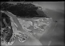
forms the southernmost part of the municipality of Thun. It extends along the railway line and the main road between Thun and Spiez . In the southeast it borders on the mouth of the Kander and the village of Einigen (municipality of Spiez). The area between Kanderdelta and Gwattlischenmoos, in which the Deltapark (formerly Gwattzentrum or Reformed Heimstätte) is located, belongs geographically and postally to Gwatt, but politically to the municipality of Spiez.
The Strättlighügel in the southwest and Lake Thun in the northeast form the natural boundaries of the village. The hamlet of Buchholz and the former village of Schoren to the north of the former village of Gwatt together form the Gwatt-Schoren-Buchholz area today. To the north of this are the Neufeld and Dürrenast districts .
history
Gwatt was first mentioned in 1296 as a wat . The name suggests a swampy landscape, with the leading G representing a plural designation. The whole lower part of the place was originally swampy and threatened by flooding. Today only the Gwattlischenmoos remains of the wetlands, which is under nature protection. However, the flat terrain remains threatened by flooding. The floods of 1999 and 2005 set the lake to new record levels and caused severe damage.
The village initially consisted mainly of individual farms on the Strättlighügel. With the increasing drainage and the construction of a new thoroughfare, the village development began to shift towards the lake in the first half of the 19th century. Industry settled in the 20th century and new residential developments emerged, through which the village eventually merged with the city of Thun.
Gwatt was the most important place in the Strättligen community . In 1920 Strättligen was incorporated into Thun.
Attractions
On the Strättlighügel above Gwatt is the Strättligturm, which was used until 1872 as a “powder tower” for the storage of gunpowder. It was built in 1700 on the spot where the Strättlig family originally lived. The facility is owned by the City of Thun and is not open to the public, but it can be rented for parties.
The Bonstettenpark is located directly on the lake. It has been publicly owned since 1960. Before that, it was part of the Bellerive estate. The building of the country estate has housed the regional music school since 1973.
The bed oak, the largest pedunculate oak in the canton of Bern, is located in the Gwatt .
literature
- Louis Hänni: Strättligen . Schaer Verlag, Thun 1997.
Web links
Aarefeld | Allmendingen | Old town | Bälliz-Freienhofgasse | Buchholz | Drought branch | Goldiwil | Gwatt | Hohmad | Lauenen-Hofstetten-Ried | Lerchenfeld | Military area | Neufeld | Shear | Seefeld | West quarter