New Milford (Connecticut)
| New Milford | ||
|---|---|---|
|
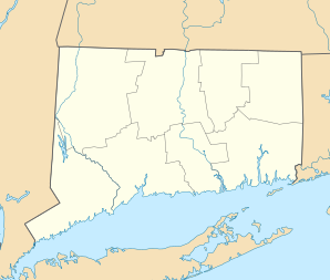
Location in Connecticut
|
||
| Basic data | ||
| Foundation : | 1707 | |
| State : | United States | |
| State : | Connecticut | |
| County : | Litchfield County | |
| Coordinates : | 41 ° 35 ′ N , 73 ° 24 ′ W | |
| Time zone : | Eastern ( UTC − 5 / −4 ) | |
| Residents : | 28,667 (as of 2005) | |
| Population density : | 179.7 inhabitants per km 2 | |
| Area : | 165.0 km 2 (approx. 64 mi 2 ) of which 159.5 km 2 (approx. 62 mi 2 ) are land |
|
| Height : | 86 m | |
| Postcodes : | 06755, 06776 | |
| Area code : | +1 860 | |
| FIPS : | 09-52630 | |
| GNIS ID : | 0213474 | |
| Website : | www.newmilford.org | |
| Mayor : | Patricia A. Murphy | |
New Milford is a city in the US state of Connecticut , United States , with a population of 28,400 (as of 2004) and the seat of the county administration.
geography
Geographical location
The place is on the northwestern shore of Candlewood Lake . Three rivers run through the city's soft surface : the Aspetuck River , the Still River, and the Housatonic River .
Neighboring communities
The neighboring parishes of New Milford are Northville to the north (4 km), Roxbury to the east (6 km), Lanesville to the south (3 km) and Sherman to the west (5 km). The next larger towns are Danbury in the south (about 15 km as the crow flies) and Waterbury in the east (about 18 km away).
City structure
The place consists of 10 boroughs, most of which were originally independent parishes: Boardman Bridge, Gaylordsville, Lower Merryall, Merwinsville, New Milford Center, Northville, Park Lane, Still River, Upper Merryall and Lanesville.
history
The first settlement of the place took place in 1707; Already on December 17, 1711, the place was officially registered as a settlement as a settlement of 12 families with a total of 70 people.
Connecticut's first rail line, opened in 1840, connected New Milford to Bridgeport. Its task was to develop agriculture and the exploitation of the region's mineral deposits. The connection is still active today as a pure freight line.
Economy and Infrastructure
traffic
The city is connected to Interstate 84 by US Highway 7 . This connection was expanded to four lanes in 2007. In addition, US Route 202 , which runs parallel to the coast, runs through the town. The Housatonic Area Regional Transit maintains several fixed bus routes to the surrounding area. There is also a rail link to the coast via the Danbury Branch of the Metro-North Railroad .
Personalities
sons and daughters of the town
- Elijah Boardman (1760–1823), United States politician and senator
Personalities who have worked on site
- Roger Sherman (1721–1793), co-signer of the American Declaration of Independence
- Karl Borromäus Frank (1893–1969), publicist, politician and psychoanalyst
- Warren Weaver (1894–1978), mathematician and computer scientist
- Malcolm Cowley (1898-1989), writer
- Heinz Pol (1901–1972), German writer and film critic
- Skitch Henderson (1918–2005), pianist and conductor
- Henry Kissinger , former United States Secretary of State
Individual evidence
- ↑ Archived copy ( Memento of the original from May 19, 2009 in the Internet Archive ) Info: The archive link was inserted automatically and has not yet been checked. Please check the original and archive link according to the instructions and then remove this notice.
- ↑ http://newyork.construction.com/news/redevnews/archive/2008/07.asp
