Nidelva (Trøndelag)
|
Nidelva Nidar, Nidelv |
||
|
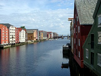
Old storage houses by the river in Trondheim |
||
| Data | ||
| Water code | NO : 123.Z | |
| location | Trøndelag ( Norway ) | |
| River system | Nea-Nidelvvassdraget | |
| Drain over | Trondheimsfjord → Atlantic Ocean | |
| origin |
Selbusjøen 63 ° 15 ′ 28 " N , 10 ° 31 ′ 41" E |
|
| Source height | 157 m | |
| muzzle | in Trondheim in the Trondheimsfjord Coordinates: 63 ° 26 '31 " N , 10 ° 24' 47" E 63 ° 26 '31 " N , 10 ° 24' 47" E |
|
| Mouth height | 0 m | |
| Height difference | 157 m | |
| Bottom slope | 5.2 ‰ | |
| length | 30 km | |
| Catchment area | 3100 km² | |
| Big cities | Trondheim | |
The Nidelva (also Nidar or Nidelv ) is an approx. 30 km long river in Fylke Trøndelag in Norway . The river has its origin in Lake Selbusjøen in Brøttem in Trondheim municipality . From there it runs northwards past the Tiller district to the Leir Falls. At this point it feeds two hydropower plants . In the lower reaches, it meanders through the town of Stavne and the center of Trondheim. On the outskirts of the city it flows into the Trondheimsfjord at Brattøra . Until the 1980s, several shipyards and shipbuilding companies were located at its mouth . Today, in addition to a marina, there is also the Nedre Elvehavn quarter , a district of Trondheim.
Web links
Commons : Nidelva, Trøndelag - collection of images, videos and audio files
