
Niederfeldbach (Töss)
| Niederfeldbach | ||
|
|
||
| Data | ||
| Water code | CH : ZH1012740000 | |
| location |
Switzerland
|
|
| River system | Rhine | |
| Drain over | Töss → Rhine → North Sea | |
| Headwaters | on the Beerenberg south of the monastery ruins 47 ° 30 ′ 22 ″ N , 8 ° 39 ′ 58 ″ E |
|
| Source height | approx. 530 m above sea level M. | |
| muzzle | north of the Hardau settlement in the Töss coordinates: 47 ° 30 ′ 55 ″ N , 8 ° 40 ′ 47 ″ E ; CH1903: 693 494 / 263 457 47 ° 30 '55 " N , 8 ° 40' 47" O |
|
| Mouth height | 438 m above sea level M. | |
| Height difference | approx. 92 m | |
| Bottom slope | approx. 57 ‰ | |
| length | 1.6 km | |
| Catchment area | 1.68 km² | |
| Left tributaries | Tannholzbach | |
| Big cities | Winterthur | |
The Niederfeldbach is a 1.6 kilometer left tributary of the Töss in Winterthur - Wülflingen , Switzerland .
geography
course
The stream rises at 511 m above sea level. M. on the Beerenberg south of the Beerenberg monastery ruins . Early after the source, the brook flows through a small pond near the Upper Berenbergstrasse.
From the pond, the brook flows for around 500 meters to the eastern edge of the forest at the beginning of Niederfeldstrasse, where the brook takes up the Tannholzbach on the left and is overturned and invisible for almost the rest of its course. Only for a 100-meter-long stretch is the brook on the surface until it flows into the Töss. The stream also crosses under the Hardau settlement.
As part of the renovation for a flood of the century , however, a renaturization and exposure of the stream is planned for the last 375 meters up to the 100 meter long exposed section. The brook would flow around the Hardau settlement and flow into the water channel of the small hydropower station Hard. A corresponding plan was published by the city of Winterthur in November / December 2018. The total project costs are between CHF 600,000 and CHF 800,000, of which CHF 300,000 will be borne by the City of Winterthur.
Catchment area
The catchment area of the brook covers around 1.68 km² and extends over part of the Beerenberg, a large part of the area north of the Aussenwacht Neuburg including the Schweikhof, the Wieshof and the Hüslihof as well as a large part of the Niederfeld district.
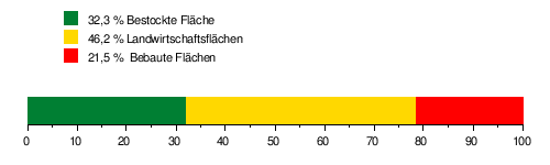
The area of its catchment area consists of 32.3% wooded area , 46.2% agricultural area and 21.5% settlement area .
The mean height of the catchment area is 465 m above sea level. M. , the minimum height is 438 m above sea level. M. and the maximum height at 596 m above sea level. M.
Tributaries
- Tannholzbach ( left ), 460 m
Individual evidence
- ↑ a b c GIS browser Canton Zurich, accessed on November 10, 2019
- ↑ Geoserver of the Swiss Federal Administration ( information )
- ↑ Till millet grain: brought out of oblivion . In: The Landbote . 182nd year, no. 267 , November 16, 2018, p. 5 .
- ↑ see area of influence of the Niederfeldbach