Niman
|
Niman Нима́н |
||
|
|
||
| Data | ||
| Water code | RU : 20030500112118100042429 | |
| location | Khabarovsk Region , Amur Oblast ( Russia ) | |
| River system | Amur | |
| Drain over | Bureja → Amur → Tatar Sound | |
| source | in the foothills of Esopkamms 52 ° 12 '26 " N , 134 ° 17' 19" O |
|
| muzzle | in the Bureja coordinates: 51 ° 25 '25 " N , 132 ° 45' 49" E 51 ° 25 '25 " N , 132 ° 45' 49" E
|
|
| length | 353 km | |
| Catchment area | 16,500 km² | |
| Outflow location: 12 km above the mouth |
MQ |
224 m³ / s |
|
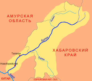
Location of the Niman (Нима́н) in the catchment area of the Bureja |
||
The Niman ( Russian: Нима́н ) is a right tributary of the Bureja in the Khabarovsk region in the Far East of Russia .
The Niman rises at the foothills of the Esop ridge ( хребѐт Эзоп ). It flows first in a westerly direction, later turns south and forms the border with Amur Oblast for several kilometers . Finally it turns to the southeast and after 353 km it meets the Bureja. The Niman drains an area of 16,500 m³ / s. From April to September the river has high water , while in winter it has low water. The mean discharge (MQ) 12 kilometers above the mouth is 224 m³ / s. The largest measured flow rate is 5030 m³ / s, the smallest 0.08 m³ / s.
Individual evidence
- ↑ a b c d Article Niman in the Great Soviet Encyclopedia (BSE) , 3rd edition 1969–1978 (Russian)
- ↑ a b Niman in the State Water Register of the Russian Federation (Russian)
