Nimerich
| Nimerich | ||
|---|---|---|
|
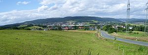
The Nimerich from the southeast |
||
| height | 532.8 m above sea level NN | |
| location | Dautphetal , Marburg-Biedenkopf district | |
| Mountains | Breidenbacher Grund , Gladenbacher Bergland | |
| Dominance | 1.9 km → Schwarzenberg | |
| Notch height | 65 m ↓ between Frankenkopf and Schwarzenberg ( location ) | |
| Coordinates | 50 ° 52 '34 " N , 8 ° 30' 54" E | |
|
|
||
The Nimerich is a 533 meter high mountain in the Schwarzenberg forest / ridge of the Breidenbacher Grund , Gladenbacher Bergland . It is located northwest of Dautphe and is the second highest point in the municipality of Dautphetal .
The Nimerich is located about 2 km southeast of the Schwarzenberg main summit and is surrounded by forest for more than 1 km even to the south.
Location and neighboring peaks
The Nimerich is located about 2 km southeast of the Schwarzenberg main summit and is surrounded by more than 1 km of forest in southern directions.
Neighboring peaks are:
- Thalenberg (a good 480 m) - 1.9 km (north) northeast near Eckelshausen
- Beilstein (461 m) - 1.2 km southeast at Wolfgruben
- Weißenberg (426 m) - 1.2 km south-southwest near Silberg
- Eichelberg (510 m) - 2.4 km west-southwest near Wolzhausen

