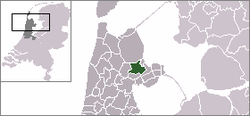
Noorder-Koggenland
 flag |
 coat of arms |
| province |
|
| local community |
|
|
Area - land - water |
50.59 km 2 49.74 km 2 0.85 km 2 |
| Residents | 10,596 (Dec. 31, 2006) |
| Coordinates | 52 ° 43 ' N , 5 ° 4' E |
| Important traffic route |
|
| prefix | 0227, 0229 |
| Postcodes | 1654-1657, 1674-1679, 1691, 1692 |
Noorder-Koggenland ( ) was a municipality in West Friesland in the Dutch province of North Holland .
The municipality was created on January 1, 1979 through the merger of the previous municipalities Abbekerk, Midwoud, Opperdoes, Sijbekarspel and Twisk and the district Hauwert of the previous municipality Nibbixwoud. Since January 1, 2007, the municipality has been part of the new municipality of Medemblik together with Wognum .
Districts
Abbekerk, Benningbroek, Hauwert, Lambertschaag, Midwoud, Oostwoud, Opperdoes, Sijbekarspel and Twisk.
politics
Distribution of seats in the municipal council
| Political party | Seats | |||
|---|---|---|---|---|
| 1990 | 1994 | 1998 | 2002 | |
| Community concerns | 4th | 4th | 7th | 3 |
| Leefbaarheid Dorpslinten | - | - | - | 3 |
| PvdA | 4th | 3 | 2 | 3 |
| CDA | 3 | 2 | 3 | 3 |
| VVD | 2 | 2 | 2 | 2 |
| D66 | - | 2 | 1 | 1 |
| total | 13 | 13 | 15th | 15th |
Web links
Commons : Noorder-Koggenland - collection of images, videos and audio files
Individual evidence
- ↑ Bevolkingsontwikkeling; regio per maand Centraal Bureau voor de Statistiek , accessed on May 17, 2018 (Dutch)
- ↑ Allocation of seats in the municipal council , accessed on May 17, 2018 (Dutch)
