Nora (Selemdscha)
|
Nora Нора |
||
|
|
||
| Data | ||
| Water code | RU : 20030400312118100036740 | |
| location | Amur Oblast ( Russia ) | |
| River system | Amur | |
| Drain over | Selemsha → Seja → Amur → Tatar Sound | |
| source |
Jagdy Mountains 53 ° 48 ′ 3 ″ N , 131 ° 4 ′ 21 ″ E |
|
| muzzle | in the Selemdscha coordinates: 52 ° 25 ′ 20 ″ N , 129 ° 56 ′ 20 ″ E 52 ° 25 ′ 20 ″ N , 129 ° 56 ′ 20 ″ E
|
|
| length | 305 km | |
| Catchment area | 16,700 km² | |
| Drainage location: 141 km above the mouth |
MQ |
128 m³ / s |
| Left tributaries | Egor | |
| Right tributaries | Dugda | |
|
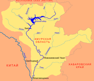
Location of the Nora (Нора) in the catchment area of the Seja |
||
The Nora ( Russian Нора ) is a right tributary of the Selemjah in the Amur Oblast in the Far East of Russia .
The Nora rises on the southern flank of the Jagdy Mountains . It flows mainly in a south-westerly direction through the Amur-Seja plain . After 305 km it reaches the Selemdscha, into which it flows on the right. In the lower reaches the Nora splits into two arms of the river. The Nora drains an area of 16,700 km². The river is flooded from May to September . The mean discharge (MQ) 141 km above the mouth is 128 m³ / s. The Nora is covered in ice between November and May. The most important tributary of the Nora, the Dugda (Дугда), flows into the river at 150 kilometers on the right.
