Selemdscha
|
Selemdzha River Селемджа |
||
|
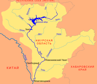
Location of the Selemjah (Селемджа) in the Seja catchment area |
||
| Data | ||
| Water code | RU : 20030400312118100033848 | |
| location | Amur Oblast (Russia) | |
| River system | Amur | |
| Drain over | Seja → Amur → Tatar Sound | |
| source |
Bureja Mountains 52 ° 26 ′ 18 ″ N , 134 ° 36 ′ 30 ″ E |
|
| Source height | ~ 1550 m | |
| muzzle | in the Seja coordinates: 51 ° 43 '58 " N , 128 ° 51' 53" E 51 ° 43 '58 " N , 128 ° 51' 53" E |
|
| Mouth height | 155 m | |
| Height difference | 1395 m | |
| Bottom slope | 2.2 ‰ | |
| length | 647 km | |
| Catchment area | 68,600 km² | |
| Discharge at the gauge near the mouth |
MNQ MQ MHQ |
5 m³ / s 715 m³ / s 10,300 m³ / s |
| Left tributaries | Ulma , Kharga , Ogodscha, Gerbikan, Byssa , Aldikon | |
| Right tributaries | Kumussan, Selitkan, Nora , Orlovka | |
| Navigable | 146 km | |
The Selemdzha River ( Russian Селемджа ) is a 647 km long left tributary of Zeya in the Russian Far East ( Asia ).
course
The Selemsha rises at an altitude of around 1550 m in the north of the Bureja Mountains , which are over 2,000 m high, on the border of the Amur Oblast and the Khabarovsk region . A few kilometers from the source, three of the main ridges of the mountains meet: Dusse-Alin from the south, Esop from the west and Jam-Alin from the north; The headwaters of the Bureja arise a little to the south .
First, the Selemdscha flows as a fast mountain river in a narrow valley to the northwest and then turns to the west, with the valley below Ekimtschan widening. The mountain chains running in an east-west direction north of this section of the river are called Selemdscha Mountains after him . To the east of Fevralsk, the river reaches the Seja-Bureja plain , along the northwestern edge of which it flows in southwestern directions.
The Selemdscha flows into the district administration center Novokijewski Uwal , about 60 kilometers northeast of the city Swobodny as its most important tributary at 155 m height in the Seja. The Selemjah flows through the territory of the Amur Oblast along its entire length .
The largest tributaries are Kumussan, Selitkan, Nora and Orlowka from the right and Ulma , Charga , Ogodscha, Gerbikan, Byssa and Aldikon from the left. In the catchment area of the river there are around 4500 lakes with a total area of more than 270 km².
Hydrography
The catchment area of the Selemdscha covers 68,600 km². Near the mouth, the river is up to 300 meters wide and over three meters deep; the flow velocity is 0.8 m / s.
The mean water flow near the mouth is 715 m³ / s, with a minimum of only 5 m³ / s in March and an absolute maximum of 10,300 m³ / s in June.
The Selemsha freezes between the beginning of November and the beginning of May.
Economy and Infrastructure
The Selemdscha is navigable for 146 kilometers from the village of Norsk, below the confluence of the Nora. When the water level is high, it is navigable for another 200 kilometers to Ekimchan .
At the end of the 19th century, gold mining began in the upper Selemsha region . In 1882 a first settlement was built on the site of today's Ekimtschan (administrative center of the raion of the same name, which encompasses the entire area of the Selemdscha upper and middle reaches). Gold mining intensified during the Soviet period: in the 1940s and 1950s, the urban-type settlements Koboldo and Stoiba directly on the Selemdscha and Tokur , Zlatoustovsk and Ogodscha on their tributaries emerged. These places can be reached via a road that branches off the M58 Amur road at Svobodny and follows the Seja, then the Selemdscha in sections in the immediate vicinity.
Since the 1980s, the Baikal-Amur Magistrale has crossed the middle reaches of the Selemdscha on a 700 meter long bridge, one of the longest in the route. A larger railway station with an associated settlement was built not far away. Fevralsk , founded in 1896 and elevated to an urban-type settlement in 1982, is now the largest town on the river with almost 5,000 inhabitants. There is no bridge along the road to Ekimchan, but a ferry 30 kilometers above Fevralsk near the village of Selemjinsk.
Individual evidence
- ↑ a b Article Selemsha in the Great Soviet Encyclopedia (BSE) , 3rd edition 1969–1978 (Russian)
- ↑ a b Selemsha in the State Water Register of the Russian Federation (Russian)
- ↑ List of Inland Waterways of the Russian Federation (confirmed by Order No. 1800 of the Government of the Russian Federation of December 19, 2002)
