
Wetterstein peaks
| Upper Wettersteinspitze | ||
|---|---|---|
 Obere Wettersteinspitze from Lautersee |
||
| height | 2298 m | |
| location | Bavaria , Germany ; Tyrol , Austria | |
| Mountains | Wetterstein Mountains , Northern Limestone Alps | |
| Dominance | 1.3 km → Rotplattenspitze | |
| Notch height | 43 m ↓ lunch slot | |
| Coordinates | 47 ° 25 '36 " N , 11 ° 11' 31" E | |
|
||
| Normal way | Via ferrata passages and I-er climbing areas | |
 The Wetterstein peaks from the south, from the Weidachsee |
||

The Wetterstein peaks in the Wetterstein Mountains are the easternmost foothills of the Wetterstein main ridge , which runs east from the Meilerhütte towards Mittenwald . They are formed from the Upper Wettersteinspitze (also Great Wetterstein ) ( 2298 m cross summit, 2305 m main summit) in the west and the Lower Wettersteinspitze (also Gemskopf ) ( 2151 m ) in the east. The border between Germany and Austria runs over the two peaks .
From Mittenwald the path leads to the Obere Wettersteinspitze past Lautersee and Ferchensee . Path 875 begins west of Lake Ferchensee and heads south-west to the Gemsanger saddle. Some rock passages are insured with wire ropes. From there the marked path (rock I) runs to the summit.
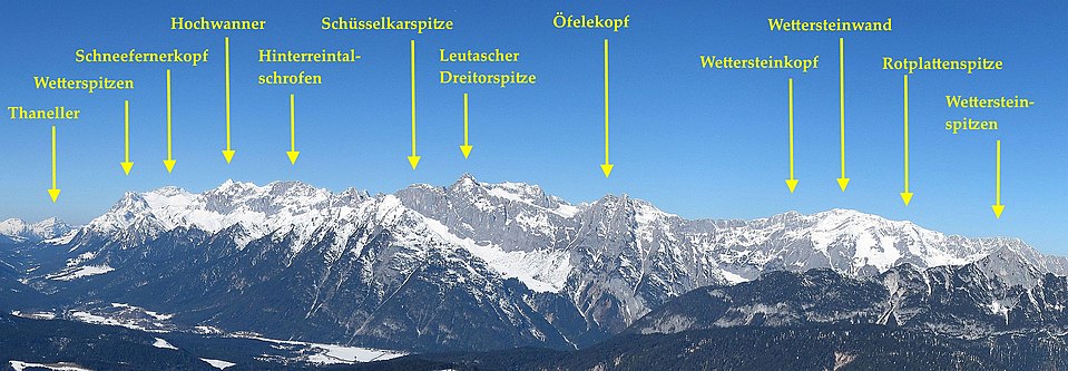
The Wetterstein peaks in the Wetterstein main ridge

literature
- Alpine Club Map 1: 25,000, sheet 4/3, Wetterstein and Mieminger Mountains, eastern sheet
- Kompass hiking, biking and ski touring map: Sheet 25 Zugspitze, Mieminger chain (1: 50,000). Compass maps, Innsbruck 2008, ISBN 978-3-85491-026-8
Web links
- Tour report "Obere Wettersteinspitze"
- Tour description Obere Wettersteinspitze