Oberlauterbach (Wolnzach)
|
Oberlauterbach
Wolnzach market
Coordinates: 48 ° 37 ′ 18 ″ N , 11 ° 39 ′ 52 ″ E
|
||
|---|---|---|
| Incorporation : | January 1, 1978 | |
| Postal code : | 85283 | |
| Area code : | 08442 | |
|
Location of Oberlauterbach in Bavaria |
||
Oberlauterbach is a district of the Wolnzach market in the Upper Bavarian district of Pfaffenhofen an der Ilm . The parish village is located in the fertile Tertiary hill country of the Hallertau , the largest contiguous hop growing area in the world.
history
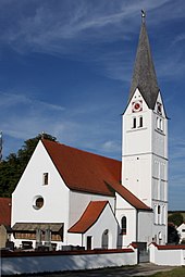
The Catholic parish church of St. Andreas is a plastered hall church with a retracted polygonal choir, transept-like side chapels and southern choir flank tower with arched friezes and pointed helmet, nave with cross vault and choir with stucco cap barrel, late Gothic choir, probably 2nd half of the 15th century, the nave around 1680, the Side chapels around 1720/30. The tower was raised in the 19th century, the pointed helmet was renewed in 1966.
In the course of the administrative reforms in Bavaria, Oberlauterbach became an independent political municipality with the municipal edict of 1818, to which the hamlet of Attenhausen also belonged. On January 1, 1978, the municipality of Oberlauterbach was incorporated into the Wolnzach market.
literature
- Franz Rutsch: The district of Pfaffenhofen. Ilmgau Verlag, 1965.
Web links
Individual evidence
- ↑ Jolanda Drexler-Herold, Angelika Wegener-Hüssen: Landkreis Pfaffenhofen ad Ilm (= Bavarian State Office for Monument Preservation [ed.]: Monuments in Bavaria . Volume I.19 ). Karl M. Lipp Verlag, Munich 1992, ISBN 3-87490-570-5 , p. 350-400 .
- ^ Federal Statistical Office (ed.): Historical municipality directory for the Federal Republic of Germany. Name, border and key number changes in municipalities, counties and administrative districts from May 27, 1970 to December 31, 1982 . W. Kohlhammer GmbH, Stuttgart / Mainz 1983, ISBN 3-17-003263-1 , p. 586 .


