Gantric
| Gantric | ||
|---|---|---|
|
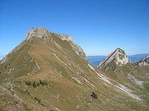
Gantrisch (front) and Nünenenflue (rear) |
||
| height | 2176 m above sea level M. | |
| location | Canton of Bern , Switzerland | |
| Mountains | Bernese Alps | |
| Dominance | 2.52 km → Ox | |
| Notch height | 218 m ↓ Morgetepass | |
| Coordinates | 600 915 / 172 617 | |
|
|
||
The Gantrisch is a 2176 m above sea level. M. high mountain in the Bernese Oberland in Switzerland . It gives its name to the Gantrisch Regional Nature Park , which started operations in 2011.
geography
Directly to the east of the Gantrisch is the summit of the Nünenenflue ( 2102 m above sea level ); the gap in between is called the ladder pass . And a little west of it are the Bürglen ( 2165 m above sea level ) and the Ochsen , which at 2188 m above sea level. M. is slightly higher. The Gantrisch is the most famous peak in this region and gives it its name.
The Stockhorn chain connects to the Gantrisch area in the east and the Gurnigel area in the north . In the south is the Simmental ; in the west the upper scythe area .
reachability
The Gantrisch area is a popular hiking and ski touring area . A hiking trail leads over the southwest ridge to the summit; the steep eastern flank has been accessible via a via ferrata since 2007 .
The Gürbe rises northeast of the Gantrisch .


